LPBF announces the release of Hydrocoast maps for the week of May 20th to May 26th
New this week:
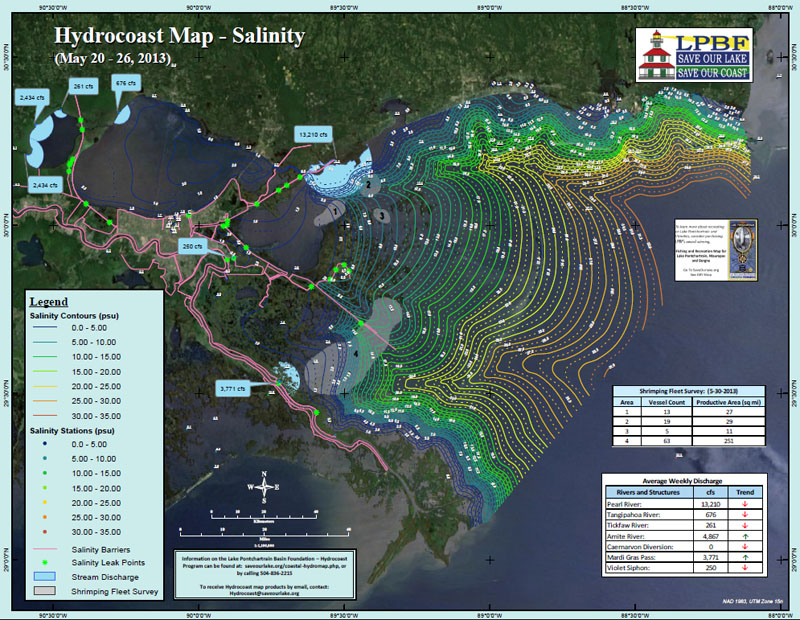
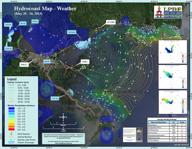
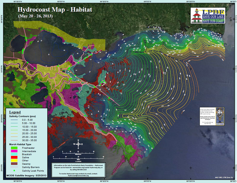
The Hydrocoast maps for the week of May 20-26 revealed little change in salinity from the last Hydrocoast period (May 6-12) and the basin remained fresh even though there was little rainfall. During this Hydrocoast period there was up to 2 inches of rain over in some areas but most areas experienced no rain or less than 1 inch. The resultant winds for this period were mostly from the northwest but also came from the north northeast. Winds ranged from 2 to 10 m/s (0 to 22 miles/hr). Average daily discharge difference between last Hydrocoast and the current was:
The results of the aerial survey for shrimp boats on May 29th revelaed that there were approximately 13 boats found on the eastern side of Lake Borgne, 19 found near Half Moon Island, 5 in the Biloxi Marshes and 63 in Eloi Bay and Breton Sound.
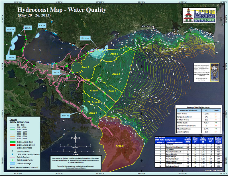
The Hydrocoast products now include a fourth "Water Quality" map which shows oyster harvest area closure, as determined by the Louisiana Department of Health and Hospitals and results of LPBF's water quality sampling around Lake Pontchartrain, reporting the water quality parameters of fecal coliform counts, water visibility, salinity and dissolved oxygen. During this Hydrocoast period, oyster harvest area 8 (spanning the Bird's Foot Delta) was closed and high fecal coliform counts were found at the Bonnabel Boat Launch and Northshore Beach.
To receive Hydrocoast products by email please email Hydrocoast@saveourlake.org with "subscribe" in the subject line. For more information on the Hydrocoast maps and to view archived maps please visit http://saveourlake.org/coastal-hydromap.php
New this week:
- A fourth "Water Quality Map"
- Results of an aerial shrimp boat count survey
The Hydrocoast maps for the week of May 20-26 revealed little change in salinity from the last Hydrocoast period (May 6-12) and the basin remained fresh even though there was little rainfall. During this Hydrocoast period there was up to 2 inches of rain over in some areas but most areas experienced no rain or less than 1 inch. The resultant winds for this period were mostly from the northwest but also came from the north northeast. Winds ranged from 2 to 10 m/s (0 to 22 miles/hr). Average daily discharge difference between last Hydrocoast and the current was:
- Pearl River = 33,757 to 13,210 cfs
- Tangipahoa = 1,602 to 676 cfs
- Tickfaw = 543 to 261 cfs
- Amite = 4,464 to 4,867 cfs Caernarvon Diversion = 1,220 to 0 cfs
- Mardi Gras Pass = 3,310 to 3,771 cfs
- Violet Siphon = 280 to 250 cfs
The results of the aerial survey for shrimp boats on May 29th revelaed that there were approximately 13 boats found on the eastern side of Lake Borgne, 19 found near Half Moon Island, 5 in the Biloxi Marshes and 63 in Eloi Bay and Breton Sound.
The Hydrocoast products now include a fourth "Water Quality" map which shows oyster harvest area closure, as determined by the Louisiana Department of Health and Hospitals and results of LPBF's water quality sampling around Lake Pontchartrain, reporting the water quality parameters of fecal coliform counts, water visibility, salinity and dissolved oxygen. During this Hydrocoast period, oyster harvest area 8 (spanning the Bird's Foot Delta) was closed and high fecal coliform counts were found at the Bonnabel Boat Launch and Northshore Beach.
To receive Hydrocoast products by email please email Hydrocoast@saveourlake.org with "subscribe" in the subject line. For more information on the Hydrocoast maps and to view archived maps please visit http://saveourlake.org/coastal-hydromap.php
###
|
To subscribe, send an email from the address you want subscribed to:
ListServer@nwrccom.cr.usgs.gov with the subject "subscribe cwppra" without the quotation marks. |
Connect with us:
|
|
|
|
||
|
Submit CWPPRA Newsflash Requests to: ruckstuhlc@usgs.gov
|
||
|
|
||
