 |
|||||||||
Follow us: |
|||||||||
LPBF announces the release of Special Edition Hydrocoast maps for the Period of June 10th to June 21st
New this week:
- Large Hypoxic area in Chandeleur Sound and Breton Sound
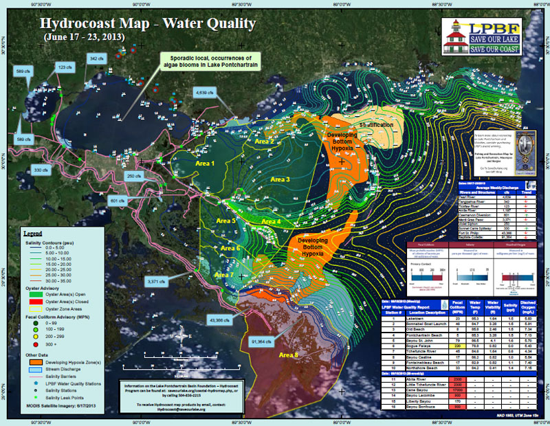
The Hydrocoast products for June 10-21 are a special edition release coinciding with LPBF's Blue Moon Cruise. The Blue Moon Cruise was an intense sampling effort conducted in June 2013 across the Pontchartrain Basin from Lake Maurepas to the Chandeleur Islands. This sampling effort collected data on water quality, submerged aquatic vegetation (SAV), fish, blue crabs, and oysters. The data used for this hydrocoast period is the water quality data collected from the cruise, in addition to the traditional sources that are used in the normal bi-weekly hydrocoast products. More in depth reports on all data collected during the Blue Moon Cruise will be released in the Summer and Fall 2013.
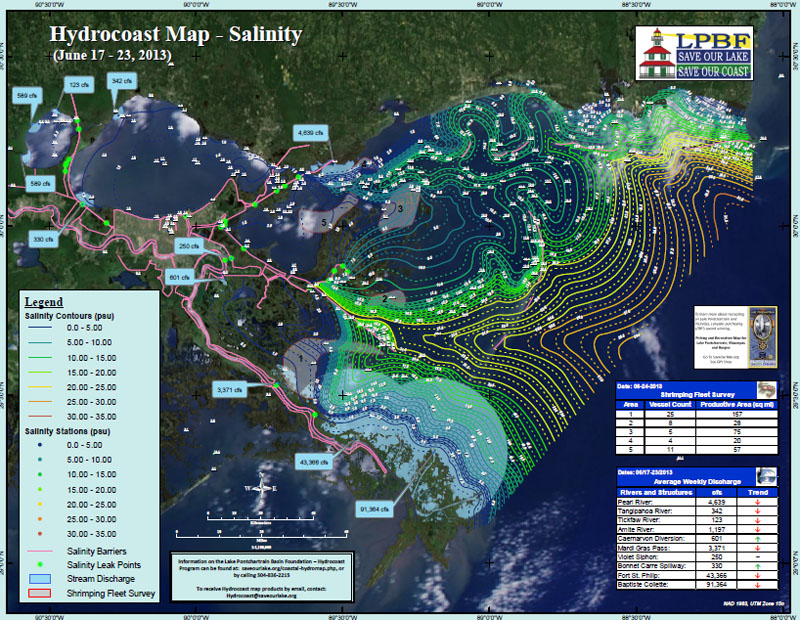
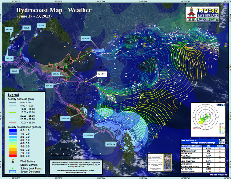
The Hydrocoast maps for the period of June 10-21 revealed that the basin remained fresh with salinity in Lake Pontchartrain mostly below 1.5 ppt and salinity in Lake Borgne mostly below 3 ppt. With the increase in water quality sampling effort for this Hydrocoast period, the effect of barrier islands blocking the influx of salt water is evident. Salinity remains fresher on the interior of the Chandeleur Islands and Cat, Ship and Horn Islands off of the Mississippi Coast. During this Hydrocoast period there was rainfall across the basin but in small amounts, usually less than 1 inch. The resultant winds for this period were mostly from the southwest and ranged from 1 to 9 m/s (2 to 20 miles/hr). Average daily discharge difference between last Hydrocoast and the current was:
The results of the aerial survey for shrimp boats on June 24 in the early morning hours revealed that there were approximately 11 boats found on the eastern side of Lake Borgne, 4 near Half Moon Island, 5 in the Biloxi Marshes, 8 in Eloi Bay and 25 Breton Sound for a total of 53 boats.
- Pearl River = 4,819 to 4,639 cfs
- Tangipahoa = 427 to 342 cfs
- Tickfaw = 143 to 123 cfs
- Amite = 1,570 to 1,197 cfs
- Caernarvon Diversion = 0 to 601 cfs
- Mardi Gras Pass = 3,653 3,371 cfs
- Violet Siphon = 250 to 250 cfs
- Bonnet Carré Spillway = 40 to 330 cfs
- Fort St. Philip = 45,009 to 43,366 cfs
- Baptiste Collete = 94,109 to 91,364 cfs
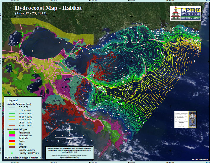
During this Hydrocoast period, oyster harvest area 8 (spanning the Bird's Foot Delta) was closed while all other areas east of the Mississippi River remained open. During this period, high fecal coliform counts were found in the Bogue Fayala, Abita River, Little Tchefuncte River, Cane Bayou, Bayou Lacombe and Bayou Bonfouca.
This special Hydrocoast period also reports on developing hypoxia and stratification found during the Blue Moon Cruise (a report on the hypoxia is available at saveourlake.org). Two areas of developing hypoxia were detected in stratified water during the Blue Moon Cruise. One was located in northern Chandeleur Sound from just south of Cat Island, extending south nearly to the bottom of the Chandeleur Islands and moving inland around the Biloxi Marshes. A second hypoxic area was found south in Breton Sound, at the end of the MRGO and extending into southern Chandeleur Sound. Stratification without low oxygen (a condition that leads to hypoxia) was found north of the Chandeleur Islands, extending out into the Gulf of Mexico about 15 miles.
To receive Hydrocoast products by email please email Hydrocoast@saveourlake.org with "subscribe" in the subject line. For more information on the Hydrocoast maps and to view archived maps please visit http://saveourlake.org/coastal-hydromap.php
###
To subscribe, send an email from the address you want subscribed to: ListServer@nwrccom.cr.usgs.gov with the subject "subscribe cwppra" without the quotation marks. |
Connect with us: |
|
Submit CWPPRA Newsflash Requests to: ruckstuhlc@usgs.gov |
||