The Breton Sound Basin is the remnant of a Mississippi River delta lobe, the abandoned
St. Bernard Delta. The principal hydrologic features of the Breton Sound Basin include the Mississippi
River and its natural levee ridges; the flood protection levee; the MRGO south
disposal bank; Bayou Terre aux Boeufs and River aux Chenes (abandoned delta
distributaries); and the freshwater diversions at Caernarvon, White's Ditch,
Bohemia, and Bayou Lamoque.
The natural processes of subsidence, saltwater intrusion, and erosion of
wetlands, and the human effects of river levee construction and the oil and gas
industry, have caused major impacts to the Breton Sound Basin in recent decades.
The two major wetland problems resulting from the natural processes and human
intervention in this basin are sediment deprivation and saltwater intrusion.
Historically, the basin was flushed with large quantities of fresh water and
sediments annually during the spring. Marine waters would then rise and enter
the basin during the late summer and early fall months and would be flushed out
the following spring. In the early 1930's, flood protection levees were raised
along the Mississippi River as far south as Bohemia in the Breton Sound Basin.
This prevented the annual input of fresh water, nutrients, and sediment that
nourished the wetlands and combatted saltwater intrusion.
Between 1940 and 1970, 12.9 square miles (8,256 acres) of canals were dredged
across and between the abandoned distributary ridges that run from the river to
the outer fringes of the marsh (Gagliano et al., 1970). This has allowed
channelized outflow of fresh water and increased tidal flux.
The combination of natural processes and human intervention has allowed salt
water to enter close to the head of the basin. Much of the fresh and
intermediate marsh that occurred in the upper basin earlier in this century has
either converted to more saline habitats or has become open water as a result of
sediment and nutrient deprivation brought about by the construction of flood
protection levees and saltwater intrusion caused by the dredging of oil and gas
access canals through and between the natural distributary ridges.
Subsidence combined with sediment and nutrient deprivation has contributed
greatly to the marsh loss in the upper and middle basin and even more greatly in
the Bohemia Subbasin. The subsidence rate ranges from 0.6 feet per century in
the upper portion of the basin to 4 feet per century in the lower portion. The
effect of subsidence is very apparent in the area south of Bohemia, which was
created by alluvial deposits of the Mississippi River less than 1,000 years ago.
Large areas of wetlands flanking the Mississippi River in this area have
subsided and are continuing to subside and convert to open water. Periodic
overbank flows from the FIGURE BS1. BASIN AND SUBBASIN
BOUNDARIES
Mississippi River occur in this area, and some wetlands immediately adjacent
to the river are being maintained by this input of sediments and fresh water.
A significant cause of wetland loss in the Breton Sound Basin is erosion of
shorelines by wind-wave action. Along the shoreline of the outer marshes and
around the perimeter of the larger bays, erosion rates of 5 to 10 feet per year
are common. These high rates occur in the fringe marshes because the Breton
barrier islands are so far offshore that they offer little protection to the
estuary behind them.
Projects in Breton Sound Basin
Summary of the Basin Plan
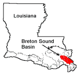
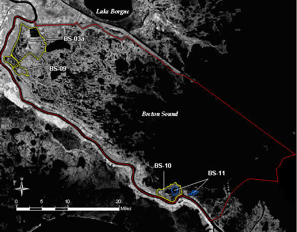
STUDY AREA
The Breton Sound Basin encompasses approximately 676,400 acres, of which
184,100 acres are wetlands. It is bounded on the west by the Mississippi River,
on the north by Bayou La Loutre, on the east by the south bank of the
Mississippi River Gulf Outlet (MRGO), and on the south by Baptiste Collette
Bayou and Breton Island (Figure BS-1). The basin includes portions of Plaquemine
and St. Bernard parishes. It consists of approximately 51,300 acres of public
land, equaling 28 percent of the total lands within the basin.
EXISTING CONDITIONS AND PROBLEMS
The Breton Sound Basin is the remnant of a Mississippi River delta lobe, the
abandoned St. Bernard Delta. The principal hydrologic features of the Breton
Sound Basin include the Mississippi River and its natural levee ridges; the
flood protection levee; the MRGO south disposal bank; Bayou Terre aux Boeufs and
River aux Chenes (abandoned delta distributaries); and the freshwater diversions
at Caernarvon, Whites Ditch, Bohemia, and Bayou Lamoque.
The natural processes of subsidence, saltwater intrusion, and erosion of
wetlands, and the human effects of river levee construction and the oil and gas
industry, have caused major impacts to the Breton Sound Basin in recent decades.
The two major wetland problems resulting from the natural processes and human
intervention in this basin are sediment deprivation and saltwater intrusion.
Historically, the basin was flushed with large quantities of fresh water and
sediments annually during the spring. Marine waters would then rise and enter
the basin during the late summer and early fall months and would be flushed out
the following spring. In the early 1930s, flood protection levees were raised
along the Mississippi River as far south as Bohemia in the Breton Sound Basin.
This prevented the annual input of fresh water, nutrients, and sediment that
nourished the wetlands and combatted saltwater intrusion.
Between 1940 and 1970, 12.9 square miles (8,256 acres) of canals were dredged
across and between the abandoned distributary ridges that run from the river to
the outer fringes of the marsh (Gagliano et al., 1970). This has allowed
channelized outflow of fresh water and increased tidal flux.
The combination of natural processes and human intervention has allowed salt
water to enter close to the head of the basin. Much of the fresh and
intermediate marsh that occurred in the upper basin earlier in this century has
either converted to more saline habitats or has become open water as a result of
sediment and nutrient deprivation brought about by the construction of flood
protection levees and saltwater intrusion caused by the dredging of oil and gas
access canals through and between the natural distributary ridges.
Subsidence combined with sediment and nutrient deprivation has contributed
greatly to the marsh loss in the upper and middle basin and even more greatly in
the Bohemia Subbasin. The subsidence rate ranges from 0.6 feet per century in
the upper portion of the basin to 4 feet per century in the lower portion. The
effect of subsidence is very apparent in the area south of Bohemia, which was
created by alluvial deposits of the Mississippi River less than 1,000 years ago.
Large areas of wetlands flanking the Mississippi River in this area have
subsided and are continuing to subside and convert to open water. Periodic
overbank flows from the FIGURE BS1. BASIN AND SUBBASIN
BOUNDARIES
Mississippi River occur in this area, and some wetlands immediately adjacent
to the river are being maintained by this input of sediments and fresh water.
A significant cause of wetland loss in the Breton Sound Basin is erosion of
shorelines by wind-wave action. Along the shoreline of the outer marshes and
around the perimeter of the larger bays, erosion rates of 5 to 10 feet per year
are common. These high rates occur in the fringe marshes because the Breton
barrier islands are so far offshore that they offer little protection to the
estuary behind them.
FUTURE WITHOUT-PROJECT CONDITIONS
Table BS-1 shows the losses estimated over the next 20 and 50 years based on
1974-1990 loss rates from Table 2.
Table BS-1
Projected Marsh Loss
Projected Loss in 20 years Projected Loss in 50 years
Subbasin (Acres) (Percent) (Acres) (Percent)
River aux Chenes 500 2 1,230 4
Caernarvon 5,100 7 12,760 16
St. Bernard 2,300 6 5,760 14
Bohemia 5,480 16 13,720 41
Total 13,380 7.3 33,470 18.2
The effects of the Caernarvon Freshwater Diversion Structure, which is
expected to preserve 320 acres per year for 50 years or 16,000 acres, are
reflected in the projected losses for the Breton Sound Basin.
Marsh loss will continue in the upper and middle parts of the basin where
sediments from the Caernarvon structure are insufficient to offset impoundment
and sediment deprivation. The marshes in the lower basin will continue to
deteriorate from wind-generated wave action and tidal scour, following the
general abandoned delta break-up process. Marshes south of Bohemia will continue
to subside, erode, and convert to open water except for those areas nearest the
river, which will be maintained by periodic overbank flow.
The economies of communities in the basin are largely based upon oil and gas
and renewable biological resources. Fishery harvests have increased, largely due
to increased numbers of harvesters, each of which is harvesting less per
man-hour than was harvested ten years ago.
BASIN PLAN
The selected plan (Figure BS-2) provides a balanced approach to create,
restore, protect, and enhance wetlands through the optimization of the available
resources afforded the basin. Management and restoration of fluvial input form
the foundation of the selected plan. In the short term, management of the
Caernarvon Freshwater Diversion Structures outfall along with outfall
management of Whites Ditch, Bohemia, and Bayou Lamoque Freshwater Diversions
is vital to the restoration of this basin because such projects will help to
maintain and restore the hydrology of the basin. Also, in the short term,
construction of a small-scale controlled sediment diversion at Grand Bay and the
restoration of overbank flow at Olga will create and nourish marsh through
sediment transport.
Restoration of fluvial input to the basin through the construction of a
20,000-cfs sediment diversion, tentatively at Bohemia, is the core of the
long-term strategy to restore the basin. A feasibility study is necessary to
determine the optimum location for such a diversion. In support of the long-term
strategies, construction of interior barriers and the restoration of natural
ridges will help to restore the natural compartmentalized hydrology within the
basin.
Projects selected for inclusion in the Breton Sound Basin plan are listed in
Table BS-2. The table indicates project type; classification (i.e., critical,
supporting); project status; acres created, restored, or protected; net
benefited acres; cost per benefited acre; and the estimated project cost.
COSTS AND BENEFITS
The proposed projects, short- and long-term critical and short-term
supporting, will create, restore, or protect approximately 5,200 acres, 39
percent of the predicted loss at an estimated cost of $11,367,000. Including
submerged aquatic vegetation and enhancement of existing marsh, an additional
4,400 acres will benefit from plan implementation.
The selected plan provides a balanced approach to improving conditions in the
basin. Hydrologic restoration measures such as outfall management and sediment
diversion account for the majority of the acres created, restored, and
protected.
If cost-effective construction techniques are developed, the Fiddler Point
Barrier Island project could be implemented. This project would protect an
additional 1,190 acres, preventing 10 percent of the projected loss. The cost of
constructing this barrier island system using present technology is estimated to
be $55,115,000. The cost per acre is $118,000 and is nearly 30 times the average
cost per acre of the other proposed projects. Thus, the recommendation is to
proceed with the rest of the plan and postpone barrier island construction until
techniques are developed to decrease their cost.
Back to Top
Dynamics of the Basin
The Breton Sound Basin is located in southeast Louisiana and encompasses
approximately 676,400 acres. It is bounded on the west by the Mississippi River,
on the north by Bayou La Loutre, on the east by the south bank of the
Mississippi River Gulf Outlet (MRGO), and on the south by Baptiste Collette
Bayou and Breton Island. Wetlands make up 184,100 acres of the basin.
Approximately 51,300 acres within the basin are public lands, equaling 28% of
the total lands within the basin (LCWCRTF 1993).
Like the Pontchartain Basin, the Breton Sound Basin is a remnant of the
Mississippi River delta lobe, the abandoned St. Bernard Delta. The principal
hydrologic features of the Breton Sound Basin include the Mississippi River and
its natural levee ridges, the flood protection levee, abandoned delta
distributaries, and the freshwater diversions at Caernarvon, White's Ditch,
Bohemia, and Bayou Lamoque. The barrier islands, which make up the Breton
National Wildlife Refuge are far offshore and thus provide minimal protection.
Elevations range from approximately +10 feet National Geodetic Vertical Datum
(NGVD) along the natural levee ridges of the Mississippi River to +2 feet NGVD
or less in the swamp and marsh areas within the basin.
Although the basin was historically flushed with large quantities of fresh
water and sediment annually during the spring, this system has suffered a series
of major human impacts, including the completion of flood-control levees along
the Mississippi River in the 1920s, construction of the MRGO in 1963, and a
labyrinth of smaller canals for oil extraction primarily from 1950 through 1980.
Thus, the estuary has been decoupled from alluvial water, sediment, and
nutrients. Subsidence rates in the basin range from 0.6 feet per century in the
upper portion of the basin to 4 feet per century in the lower basin (LCWCRTF 1993).
The immediate impact of these alterations has been increased marine
influence, including a landward shift in salinity. Much of the fresh and
intermediate marsh that existed in the upper basin earlier in this century has
either converted to more saline habitats or has become open water as a result of
sediment and nutrient deprivation, erosional processes, or a combination of
these occurrences. Secondary impacts include land loss, habitat degradation,
loss of biodiversity, and an inland shift in oyster production. Along the
shoreline of the outer marshes and around the perimeter of the larger bays,
erosion rates of 5-10 feet/year are common.
Since 1932, 47,036 acres (almost 17%) of the wetland area in the Breton Sound
Basin has converted to open water (Dunbar et al. 1992, figure 19). Without
action, approximately 1,000 acres of marsh will continue to be lost each year
(Dunbar et al. 1992, Barras et al. 1994). This loss amounts to approximately
20,000 acres during the next 20 years. If no action is taken to restore and
protect the remaining wetlands, it is projected that an additional 18% will be
lost by the year 2040.
Back to Top
Discussion
Primary concerns for projects implemented in the Breton Sound Basin include local impacts
on fishery harvest and access to oil and gas exploration and production sites. For all of
the CWPPRA projects described previously, access and productivity associated with these
industries must be addressed before CWPPRA project implementation. Although freshwater
fisheries, furbearers, waterfowl and long-term estuarine sustainability would flourish through
CWPPRA freshwater diversions, potential short-term losses to estuarine fisheries (e.g., oysters)
must also be considered.
Historically, projects to restore coastal wetlands in the Breton Sound Basin were constructed
by different entities for various management objectives. CWPPRA restoration projects in the
future may include maximization of other existing freshwater diversions in the basin,
including Bayou LaMoque, and introduction of other large-scale diversions (e.g., at the
Bohemia Spillway) such that the long-term sustainability of the estuary and its resources
can be ensured.