The basin contains about 450,000 acres of
wetlands, consisting of 190,000 acres of fresh marsh, 135,000 acres of
intermediate marsh, and 101,000 acres of brackish marsh. A total of 104,380
acres of marsh has converted to open water since 1932, a loss of 19 percent of
the historical wetlands in the basin.
Prior to human alterations, delta-building processes associated with the
Mississippi River resulted in periodic building of marsh along the gulf coast of
the Mermentau Basin. Construction of flood control and navigation projects on
the Mississippi and Atchafalaya rivers restricted those natural processes to
relatively small portions of the coast. Consequently, marsh-building now occurs
on only the eastern-most portion of the Mermentau Basins coastline. This
condition is further aggravated by continuing subsidence and sea level rise. In
the Mermentau Basin, relative sea level rise results in an average water level
rise of 0.25 inches per year. Although natural wetland building processes only
occur along the eastern shore, natural marsh maintenance processes (e.g., plant
deterioration and regeneration) can be fairly effective at keeping wetland loss
rates low. However, these processes have been altered or interrupted and the
ability of the system to maintain the marsh is jeopardized.
The two subbasins suffer from distinctly different hydrologic problems. The
most critical wetland problem in the Lakes Subbasin is excessive flooding. A
5-mile-long segment of Louisiana Highway 27 almost totally blocks drainage from
the western portion of the Lakes Subbasin into adjacent wetlands of the
Calcasieu/Sabine Basin. Similarly, along the southern boundary of the Lakes
Subbasin, Louisiana Highway 82 blocks drainage across 17 miles of marsh. The
Freshwater Bayou navigation channel has altered the historic drainage pattern in
the eastern portion of the Lakes Subbasin. These numerous blockages of drainage
outlets significantly increase ponding in the subbasin.
The Catfish Point Control Structure, built to reduce saltwater intrusion into
Grand Lake via the Mermentau River, controls the major drainage outlet from the
Lakes Subbasin. High water levels in the gulf frequently prevent the drainage of
the subbasin through the structure. Farther upstream, development and
channelization of the Mermentau River watershed have increased the rate of
run-off into the Lakes Subbasin. These factors, in combination with the loss of
historic drainage outlets, result in periods of prolonged high water levels
following heavy basin-wide precipitation. Because upland drainage improvements
are continuing
Natural freshwater inputs from the Lakes Subbasin into the marshes of the
Chenier Subbasin are reduced by the same highway embankments that impound water
in the northern subbasin. The loss of those freshwater inputs is compounded by
waterways and canals that create additional connections between the gulf and
area marshes, facilitating saltwater intrusion.
Projects in the Mermentau Basin
Summary of the Basin Plan
STUDY AREA
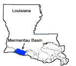
The Mermentau Basin lies in the eastern portion of the Chenier Plain in
Cameron and Vermilion Parishes. The 734,000-acre basin is bounded on the east by
Freshwater Bayou Canal, on the South by the Gulf of Mexico, on the west by
Louisiana State Highway 27, and on the north by the coastal prairie. The Grand
Chenier and Pecan Island ridge systems are linked by Louisiana Highway 82 and
divide the basin into two distinct subbasins: the Lakes Subbasin north of the
highway and the Chenier Subbasin south of the highway (Figure ME-1). About 18
percent (128,200 acres) of the basin lands are publicly owned as Federal refuges
and State wildlife management areas.
EXISTING CONDITIONS AND PROBLEMS
The basin contains about 450,000 acres of wetlands, consisting of 190,000
acres of fresh marsh, 135,000 acres of intermediate marsh, and 101,000 acres of
brackish marsh. A total of 104,380 acres of marsh has converted to open water
since 1932, a loss of 19 percent of the historical wetlands in the basin.
Prior to human alterations, delta-building processes associated with the
Mississippi River resulted in periodic building of marsh along the gulf coast of
the Mermentau Basin. Construction of flood control and navigation projects on
the Mississippi and Atchafalaya rivers restricted those natural processes to
relatively small portions of the coast. Consequently, marsh-building now occurs
on only the eastern-most portion of the Mermentau Basins coastline. This
condition is further aggravated by continuing subsidence and sea level rise. In
the Mermentau Basin, relative sea level rise results in an average water level
rise of 0.25 inches per year. Although natural wetland building processes only
occur along the eastern shore, natural marsh maintenance processes (e.g., plant
deterioration and regeneration) can be fairly effective at keeping wetland loss
rates low. However, these processes have been altered or interrupted and the
ability of the system to maintain the marsh is jeopardized.
The two subbasins suffer from distinctly different hydrologic problems. The
most critical wetland problem in the Lakes Subbasin is excessive flooding. A
5-mile-long segment of Louisiana Highway 27 almost totally blocks drainage from
the western portion of the Lakes Subbasin into adjacent wetlands of the
Calcasieu/Sabine Basin. Similarly, along the southern boundary of the Lakes
Subbasin, Louisiana Highway 82 blocks drainage across 17 miles of marsh. The
Freshwater Bayou navigation channel has altered the historic drainage pattern in
the eastern portion of the Lakes Subbasin. These numerous blockages of drainage
outlets significantly increase ponding in the subbasin.
The Catfish Point Control Structure, built to reduce saltwater intrusion into
Grand Lake via the Mermentau River, controls the major drainage outlet from the
Lakes Subbasin. High water levels in the gulf frequently prevent the drainage of
the subbasin through the structure. Farther upstream, development and
channelization of the Mermentau River watershed have increased the rate of
run-off into the Lakes Subbasin. These factors, in combination with the loss of
historic drainage outlets, result in periods of prolonged high water levels
following heavy basin-wide precipitation. Because upland drainage improvements
are continuing
Natural freshwater inputs from the Lakes Subbasin into the marshes of the
Chenier Subbasin are reduced by the same highway embankments that impound water
in the northern subbasin. The loss of those freshwater inputs is compounded by
waterways and canals that create additional connections between the gulf and
area marshes, facilitating saltwater intrusion.
FUTURE WITHOUT-PROJECT CONDITIONS
If nothing is done to solve the problem of wetland loss in this basin,
current estimates project a continuing loss rate of 1,980 ares per year. Table
ME-1 shows projected losses for 20- and 50-year periods for each subbasin.
In absence of remedial action, about 18 percent, or 62,900 acres, of the land
in the Lakes Subbasin would be lost over 50 years. This loss would occur in
wetlands adjacent to the shorelines of White and Grand Lakes and the banks of
the GIWW and Freshwater Bayou Canal. Interior losses would continue in the Deep
Lake area, the Freshwater Bayou wetlands, and the vicinity of Little Pecan
Bayou.
Chenier Subbasin wetland losses are projected to be 32 percent, or 36,100
acres, over the next 50 years. Interior wetland losses would continue to occur
south of Pecan Island and Grand Chenier. Erosion along the gulf shoreline would
continue at the present rate of 20 to 40 feet per year.
Table ME-1
Projected Marsh Loss
Projected Loss at 20 yrs. Projected Loss at 50 yrs.
Subbasin (Acres) (Percent) (Acres) (Percent)
Lakes 25,160 7.3 62,900 18.3
Chenier 14,440 12.6 36,100 31.5
Totals 39,600 8.6 99,000 21.4
BASIN PLAN
The short-term portion of the Mermentau Basin plan depends on modifying
existing structures and creating additional outlets to reduce ponding in the
Lakes Subbasin and reducing salinity intrusion in the Chenier Subbasin. In
addition, the plan utilizes shoreline protection, hydrologic restoration, marsh
creation with dredged material, marsh management, terracing, and vegetative
plantings. The long-term portion of the plan relies on hydrologic restoration
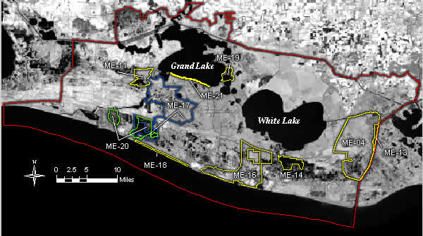
and vegetative plantings. Figure ME-2 indicates the strategy for the basin. A
detailed discussion of the plan formulation and evaluation process is in the
Mermentau Basin Plan, Appendix H.
In the Lakes Subbasin, the short-term critical projects use two methods to
move water out of the subbasin for the purpose of reducing flooding stress on
vegetated wetlands: modifying the Vermilion Lock (which is no longer
operational) and the
The short-term supporting projects within the Lakes Subbasin protect interior
wetlands by hydrologic restoration (Sawmill and Humble Canals), rebuild open
water areas (Big Burn and Deep Lake), and protect shorelines and banks (White
Lake, Freshwater Bayou, and the GIWW).
The long-term supporting projects within the Lakes Subbasin treat critical
loss areas by hydrologic restoration ( Miami South Levee and Coteau Plateau
Marsh) and vegetative plantings (Little Pecan Island and along the GIWW).
For the Chenier Subbasin, the short-term critical projects use water
evacuated from the Lakes Subbasin to treat the saltwater intrusion problem
(White Lake Diversion, Grand/White Lake Diversion, and Hog Bayou Freshwater
Introduction).
The short-term supporting projects within the Chenier Subbasin protect the
gulf shoreline from the Mermentau River to the eastern boundary of the
Rockefeller Refuge, restore hydrology (Rollover Bayou Structure), create
wetlands (Pecan Island Terracing), and plant vegetation along the gulf
shoreline.
Table ME-2 lists all the projects in the selected plan. A detailed
description of all projects in the selected plan is contained in Appendix H.
COSTS AND BENEFITS
Lakes Subbasin.
Implementation of the 30 evaluated projects in the selected plan (critical
and supporting short-term projects) will protect, create, or restore 6,710 acres
of wetlands and decrease marsh losses over a period of twenty years by an
estimated 27 percent at a cost of approximately $53,358,000. Three critical
hydrologic restoration projects in the subbasin were not evaluated for cost or
habitat benefits and will require further study and evaluation. The benefits for
these projects will depend on their ability to reduce the water levels in the
subbasin. Additional projects will need to be evaluated for the subbasin for
protection of acreage not covered under the present plan.
Chenier Subbasin.
The selected plan is expected to create, protect, or restore 3,150 acres of
wetlands and reduce marsh loss over a period of twenty years by 22 percent
at a cost of approximately $19,571,000. One project was not evaluated for cost
or habitat benefits and will require further study and evaluation. There is a
need to develop and evaluate other projects to achieve no net loss of wetlands.
If dredging technology becomes more cost-effective, the option of pumping
sediments from the gulf into shallow open water or deteriorating marshes will
need to be investigated. This can only be used in the more saline subbasin
marshes. It should only be done during the spring floods when the gulf
salinities are the lowest in order to avoid placing sediments with higher
salinities into marsh environments.
Back to Top
Dynamics of the Basin
The Mermentau Basin lies in the eastern portion of the chenier plain in
Cameron and Vermilion parishes. This 734,000-acre basin is bounded on the east
by Freshwater Bayou Channel, on the south by the Gulf of Mexico, on the west by
Louisiana Highway 27, and on the north by the GIWW (figure 27). The basin
contains about 450,000 acres of wetlands, consisting predominantly of fresh
(approximately 190,000 acres), intermediate (approximately 135,000 acres), and
brackish marsh (approximately 101,000 acres). The basin is divided into two
distinct subbasins by the Grand Chenier and Pecan Island ridge systems, which
are linked by Louisiana Highway 82. The Lakes subbasin lies to the north, and
includes Grand and White lakes and the GIWW. The Chenier subbasin lies to the
south of Louisiana Highway 82 and includes Hog Bayou, Rockefeller Refuge, and
other marsh areas south of Pecan Island. Wetlands within the Lakes Subbasin
consist primarily of fresh marsh and submergent and floating aquatic vegetation.
Vegetation types within the Chenier Subbasin range from fresh to saline, with
fresh and intermediate marshes existing only in managed areas.
The dominant hydrologic features of the Lakes Subbasin are Grand and White
lakes, with fresh water entering the subbasin through the Mermentau River,
Lacassine Bayou, the Bell City Drainage Canal, the Gueydan Canal, the Warren
Canal, and a number of other smaller drainage canals. Major outlets for
discharge of water from the subbasin include the Catfish Point Control
Structure, the Schooner Bayou Control Structure, the East End Control Structure,
the Leland Bowman Lock, and the Freshwater Bayou Lock. A large number of water
control structures have been constructed at sites where salt water could
encroach into subbasin wetlands, such as in the Little Pecan Bayou area, east of
the Mermentau River.
The hydrology of the Chenier Subbasin is dominated by the Lower Mermentau
River and has been significantly altered through hydrologic management
activities (e.g., for cattle pasture and waterfowl protection). The Mermentau
River-Gulf of Mexico Navigation Channel has altered the hydrology of the river
by connecting the river with the gulf near Grand Chenier. This connection allows
high salinity water from the Gulf of Mexico to enter the Lower Mermentau River.
Drainage for marshes located in the western portion of the subbasin occurs
primarily via access canals and small bayous to the Gulf. The majority of
marshes between Rollover Bayou and Freshwater Bayou Channel drain eastward via
access canals into the Freshwater Bayou Channel.
The Gulf of Mexico beach is retreating across most of the Chenier Subbasin.
However, mud deposits have resulted in a progradation of the eastern shoreline.
The sediment source responsible for this progradation is likely a combination of
reworked Atchafalaya River sediments and reworked spoil from maintenance
dredging of the southern end of Freshwater Bayou Channel. In this prograding
area, the shore consists of a very broad mud flat, colonized by smooth cordgrass
on slightly elevated ridges.
A total of 117,825 acres of marsh have converted to open water since 1932,
which accounts for 18% of the historical wetlands in the Mermentau Basin (Dunbar
et al. 1992) and represents 9% of wetland loss in Louisiana. Current land loss
rates are approximately 2,600 acres/year (Dunbar et al. 1992, Barras et al.
1994). At this rate, approximately 52,000 acres of wetland will be lost during
the next 20 years (an additional 8.6% of the basin's wetlands) without
restorative action (LCWCRTF 1993). This loss is expected to continue along the
shorelines of the lakes and banks of the navigation channels in the Lakes
Subbasin, and in the interior marshes of the Chenier Subbasin (figure 27).
Erosion along the gulf shoreline is expected to continue at its present rate of
20-40 feet per year. Much of the Mermentau Basin's wetland loss is attributed to
saltwater intrusion, ponding, and reductions in freshwater and nutrient inputs.
Louisiana Highway 82 forms a north-south hydrologic barrier between the Lakes
and Chenier subbasins from Oak Grove to Pecan Island, and an east-west
hydrologic barrier between White Lake and Freshwater Bayou. The highway reduces
sheet flow, starves the downstream chenier marshes of fresh water and sediment,
and increases flooding in the Lakes Subbasin.
The most critical wetland problem in the Lakes Subbasin is excessive
flooding. Prolonged high water leads to direct wetland loss and shifts in plant
species composition. High water levels increase erosion rates along natural lake
rims that protect more fragile interior marshes that are lower in elevation.
Once the protective lake rims are lost, erosion rates accelerate. Erosion from
vessel wakes is also a problem along the GIWW and the Freshwater Bayou Channel.
Many areas within the subbasin have experienced marsh loss due to saltwater
intrusion, which mainly impacts areas adjacent to human-made channels and
dredged waterways. In these areas, salt-intolerant plants are destroyed, leaving
marsh soils unprotected. Under these conditions, the subbasin's characteristic
organic soils are easily eroded by tidal movement, resulting in the conversion
of marsh to open water.
In the Chenier Subbasin, the combination of regional and localized hydrologic
alterations associated with numerous access canals and board roads, plus the
failure and abandonment of former forced drainage areas, resulted in extensive
marsh loss. Although input of suspended sediment is currently rebuilding
deteriorated marshes in the westernmost portion of the basin, marshes within the
highly altered middle and upper portions of the basin are continuing to
experience losses. Natural freshwater inputs from the Lakes Subbasin into
marshes of the Chenier Subbasin were virtually eliminated with the construction
of Louisiana highways 27 and 82. The problem is compounded by dredging projects
that create additional connections between the Gulf and subbasin marshes,
facilitating saltwater intrusion. The natural salinity and tidal regime of the
subbasin was altered by the construction of the Freshwater Bayou Channel,
Mermentau River-Gulf of Mexico Navigation Channel, and numerous access canals.
Prior to these alterations, fresh and intermediate marshes were isolated from
tidal exchange and associated high salinities. The introduction of high-salinity
water destroyed much of the vegetation, exposing the underlying organic soils to
tidal exchange, which resulted in extensive marsh loss.
Back to Top
Discussion
In order to successfully protect, restore, and enhance the Mermentau Basin's wetlands, it
is critical that projects be implemented in the Lakes Subbasin to lower water levels and
reduce stress on interior wetlands, and in the Chenier Subbasin to restore freshwater input,
provide additional nutrients and sediment to receiving wetlands, and divert fresh water from
the Lakes Subbasin. Implementation of projects that reduce interior wetland loss, rebuild
wetlands in open water areas, and maintain the geologic framework of the basin by addressing
shoreline erosion along the lakes, navigation channels, and gulf, is also critical. Although
it is too early to determine the success of the all CWPPRA projects, preliminary indications
for completed projects' goals are being met. Although the vegetative plantings failed for the
Dewitt-Rollover project, deauthorization of this project has released funds which had been
reserved for maintenance and monitoring of the project so that these funds can be spent on
more appropriate efforts. The anticipated benefits of current and future CWPPRA projects,
along with complementary state sponsored projects, should help to maintain the integrity of
Mermentau Basin wetlands.