The Mississippi River has had a profound
effect on the landforms of coastal Louisiana. The entire area is the product of
sediment deposition following the latest rise in sea level about 5,000 years
ago. Each Mississippi River deltaic cycle was initiated by a gradual capture of
the Mississippi River by a distributary which offered a shorter route to the
Gulf of Mexico. After abandonment of an older delta lobe, which would cut off
the primary supply of fresh water and sediment, an area would undergo
compaction, subsidence, and erosion. The old delta lobe would begin to retreat
as the gulf advanced, forming lakes, bays, and sounds. Concurrently, a new delta
lobe would begin its advance gulfward. This deltaic process has, over the past
5,000 years, caused the coastline of south Louisiana to advance gulfward from 15
to 50 miles, forming the present-day coastal plain.
For the last 1,200 years, sediment deposition has occurred primarily at the
mouth of the Mississippi River's Plaquemines-Balize delta, in the area defined
as the Mississippi River Delta Basin. This delta is located on the edge of the
continental shelf of the Gulf of Mexico. Its bird's foot configuration is
characteristic of alluvial deposition in deep water. In this configuration large
volumes of sediment are required to create land area; consequently, land is
being lost in this delta more rapidly than it is being created.
The Mississippi River Delta Basin comprises approximately 521,000 acres of
land and shallow estuarine water area in the active Mississippi River delta.
Approximately 83 percent of this area, or 420,000 acres, is open water. The
101,100 acres of land in the basin are characterized by low relief, with the
most prominent features being natural channel banks and dredged material
disposal areas along the Mississippi River, its passes, and man-made channels.
Coastal marshes make up approximately 61,650 acres or about 61 percent of the
total land area in the Mississippi River Delta Basin. Eighty-one percent of this
marsh is fresh, 17 percent is intermediate, and 2 percent is brackish-saline.
The Mississippi River discharges the headwater flows from about 41 percent of
the contiguous 48 states. On a long-term daily basis, discharges in the
Mississippi River average 470,000 cubic feet per second (cfs). A peak discharge
of approximately 1,250,000 cfs occurs on the average of once every 16 years
downstream of New Orleans.
Suspended sediment concentrations in the river decreased markedly between
1950 and 1966. Since that time the observed decrease in the suspended sediment
load has been minimal. Long-term suspended sediment loads in the river average
436,000 tons per day; they have ranged from an average of 1,576,000 tons per day
in 1951 to a still considerable average of 219,000 tons per day in 1988.
Between 1974 and 1990 the land loss rate in the Mississippi River Delta Basin
averaged 1,072 acres per year, or 1.69 percent of existing land area (Dunbar,
Britsch, and Kemp 1992). Between the mid-1950's and 1974, the estimated land
loss rate for the basin was 2,890 acres per year. This loss is the result of
compaction, subsidence, hurricanes, tidal erosion, sea level rise, and human
activities. The loss has been aggravated by maintenance of navigation channels
and construction of canals for mineral exploration. The total land area lost in
this basin over the last 60 years has been approximately 113,300 acres.
The primary wetlands loss problem facing the Mississippi River Delta Basin is
that of subsidence and compaction. Unlike other areas of coastal Louisiana, the
Mississippi River delta is blessed with a relative abundance of inflowing fresh
water and sediments. Despite the availability of these resources, the overall
growth of emergent delta has been truncated in recent history. In its present
position the Mississippi River deposits sediments into much deeper water than
has been the case historically. This is evidenced by the thick stratum of
Holocene deltaic sediments found in the active river delta. These unconsolidated
sediments are highly susceptible to compaction, reducing the life span of
emergent wetlands. While the rapid emergence of wetlands can occur over large
areas in the delta, these areas deteriorate in an equally rapid manner.
Human activities have aggravated land loss rates in the Plaquemines-Balize
delta. The stabilization of the Mississippi River's channel has cut off seasonal
sediment-laden overbank flow that once nourished adjacent wetland areas. The
Mississippi River levees to the north, and associated erosion control and
channel stabilization measures extending to its mouth, also preclude the
possibility of a naturally occurring crevasse or change in the river's course.
Many areas of the Louisiana coast suffer from a lack of the abundant fresh
water and sediment found in the Mississippi River. Since the river is no longer
free to alter its course and leave its banks to inundate vast coastal areas, the
effects of human and natural forces which promote wetland deterioration are
compounded. In this respect the relationship between the Mississippi River and
the problems facing coastal wetlands is not limited to the river's delta, but
extends across the entire Louisiana coast. The lack of growth in the Mississippi
River delta, on a large scale, is as much a coast-wide problem as a basin
problem. This source of ample fresh water and sediment, which shaped the
Louisiana coast as we know it, is no longer producing a net gain in coastal
wetlands, placing the entire Louisiana coast at risk.
Projects in the Mississippi River Delta Basin
Summary of the Basin Plan
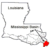
STUDY AREA
The Mississippi River Delta Basin is defined as all of the land and shallow
estuarine area between the two northernmost passes of the Mississippi River and
the Gulf of Mexico. The basin is located in Plaquemines Parish, Louisiana, south
of the city of Venice. Baptiste Collette Bayou, on the east side of the river,
and Red Pass, on the west side, form the basin's northern boundary. This area is
also referred to as the Plaquemines-Balize or "bird's foot" delta. The
basin encompasses approximately 521,000 acres and is shown in Figure MR-1.
Approximately 129,000 acres of land and water in this basin are in public
ownership. This includes approximately 14,000 acres of the river's channel and
passes which are navigable waterways of the United States.
EXISTING CONDITIONS AND PROBLEMS
The Mississippi River has had a profound effect on the landforms of coastal
Louisiana. The entire area is the product of sediment deposition following the
latest rise in sea level about 5,000 years ago. Each Mississippi River deltaic
cycle was initiated by a gradual capture of the Mississippi River by a
distributary which offered a shorter route to the Gulf of Mexico. After
abandonment of an older delta lobe, which would cut off the primary supply of
fresh water and sediment, an area would undergo compaction, subsidence, and
erosion. The old delta lobe would begin to retreat as the gulf advanced, forming
lakes, bays, and sounds. Concurrently, a new delta lobe would begin its advance
gulfward. This deltaic process has, over the past 5,000 years, caused the
coastline of south Louisiana to advance gulfward from 15 to 50 miles, forming
the present-day coastal plain.
For the last 1,200 years, sediment deposition has occurred primarily at the
mouth of the Mississippi River's Plaquemines-Balize delta, in the area defined
as the Mississippi River Delta Basin. This delta is located on the edge of the
continental shelf of the Gulf of Mexico. Its bird's foot configuration is
characteristic of alluvial deposition in deep water. In this configuration large
volumes of sediment are required to create land area; consequently, land is
being lost in this delta more rapidly than it is being created.
The Mississippi River Delta Basin comprises approximately 521,000 acres of
land and shallow estuarine water area in the active Mississippi River delta.
Approximately 83 percent of this area, or 420,000 acres, is open water. The
101,100 acres of land in the basin are characterized by low relief, with the
most prominent features being natural channel banks and dredged material
disposal areas along the Mississippi River, its passes, and man-made channels.
Coastal marshes make up approximately 61,650 acres or about 61 percent of the
total land area in the Mississippi River Delta Basin. Eighty-one percent of this
marsh is fresh, 17 percent is intermediate, and 2 percent is brackish-saline.
The Mississippi River discharges the headwater flows from about 41 percent of
the contiguous 48 states. On a long-term daily basis, discharges in the
Mississippi River average 470,000 cubic feet per second (cfs). A peak discharge
of approximately 1,250,000 cfs occurs on the average of once every 16 years
downstream of New Orleans.
Figure MR-1, Mississippi River Delta Basin Area
Suspended sediment concentrations in the river decreased markedly between
1950 and 1966. Since that time the observed decrease in the suspended sediment
load has been minimal. Long-term suspended sediment loads in the river average
436,000 tons per day; they have ranged from an average of 1,576,000 tons per day
in 1951 to a still considerable average of 219,000 tons per day in 1988.
Between 1974 and 1990 the land loss rate in the Mississippi River Delta Basin
averaged 1,072 acres per year, or 1.69 percent of existing land area (Dunbar,
Britsch, and Kemp 1992). Between the mid-1950's and 1974, the estimated land
loss rate for the basin was 2,890 acres per year. This loss is the result of
compaction, subsidence, hurricanes, tidal erosion, sea level rise, and human
activities. The loss has been aggravated by maintenance of navigation channels
and construction of canals for mineral exploration. The total land area lost in
this basin over the last 60 years has been approximately 113,300 acres.
The primary wetlands loss problem facing the Mississippi River Delta Basin is
that of subsidence and compaction. Unlike other areas of coastal Louisiana, the
Mississippi River delta is blessed with a relative abundance of inflowing fresh
water and sediments. Despite the availability of these resources, the overall
growth of emergent delta has been truncated in recent history. In its present
position the Mississippi River deposits sediments into much deeper water than
has been the case historically. This is evidenced by the thick stratum of
Holocene deltaic sediments found in the active river delta. These unconsolidated
sediments are highly susceptible to compaction, reducing the life span of
emergent wetlands. While the rapid emergence of wetlands can occur over large
areas in the delta, these areas deteriorate in an equally rapid manner.
Human activities have aggravated land loss rates in the Plaquemines-Balize
delta. The stabilization of the Mississippi River's channel has cut off seasonal
sediment-laden overbank flow that once nourished adjacent wetland areas. The
Mississippi River levees to the north, and associated erosion control and
channel stabilization measures extending to its mouth, also preclude the
possibility of a naturally occurring crevasse or change in the river's course.
Many areas of the Louisiana coast suffer from a lack of the abundant fresh
water and sediment found in the Mississippi River. Since the river is no longer
free to alter its course and leave its banks to inundate vast coastal areas, the
effects of human and natural forces which promote wetland deterioration are
compounded. In this respect the relationship between the Mississippi River and
the problems facing coastal wetlands is not limited to the river's delta, but
extends across the entire Louisiana coast. The lack of growth in the Mississippi
River delta, on a large scale, is as much a coast-wide problem as a basin
problem. This source of ample fresh water and sediment, which shaped the
Louisiana coast as we know it, is no longer producing a net gain in coastal
wetlands, placing the entire Louisiana coast at risk.
FUTURE WITHOUT-PROJECT CONDITIONS
Since 1932, the Mississippi River Delta Basin has lost approximately 70
percent of its total land area. The composite of recent loss rates presented
above was used to predict future wetlands losses. The total projected wetland
losses over 20- and 50year time spans represent, respectively, 35 and 87
percent of the existing wetlands in the basin and are shown in Table MR-1. Based
on this loss of wetlands, only 5 percent of the original 1932 land area in
this basin would remain intact in 50 years.
Table MR-1
Projected Wetland Losses
Projected Time (years) Acres Lost Percent Loss
20 21,440 35
50 53,600 87
BASIN PLAN
The unique opportunity present in this basin is the tremendous volume of
sediment transported by the Mississippi River. The need which must be addressed
with this resource is not limited to only this basin. The needs of the entire
coast of Louisiana are linked, inseparably, to the unique opportunity that the
Mississippi River presents.
Two alternative strategies were developed for this basin. Strategy One
involves the study and development of a major uncontrolled diversion of the
Mississippi River for the creation of a new delta, while maintaining the
navigation route in its present location and managing the retreat of the
existing delta. Strategy Two would maintain the course of the river in its
present location and optimize the growth of the existing delta through
redistribution of the available flows and sediments throughout this location.
The crucial point for the selection of the diversion plan, Strategy One, over
Strategy Two, maintenance of the existing delta, is the extent of the benefits
which can be achieved and the long-term optimization of available resources.
Diversion of
the river's main flow translates into large gains in newly emergent wetlands
over potentially hundreds of years. It should also be recognized that the
existing delta, if left to natural processes, would ultimately be abandoned and
its wetlands lost.
It is also important to note that the same short-term strategy can be
implemented under either major strategy. Many of the measures which can be taken
to enhance the current delta configuration under Strategy Two will, in some
scaled form, be used in preparing the existing delta for a diversion of the
river and in managing its retreat under Strategy One. This allows the execution
of the plan to proceed in the short term regardless of which major diversions
may ultimately prove feasible.
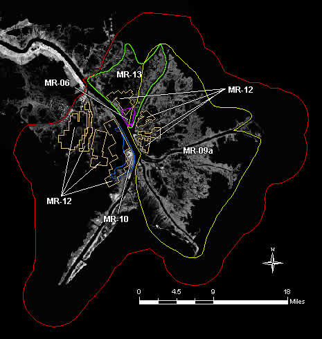
Under the selected course of action, Strategy One, the proposed study would
look into all viable options for undertaking the relocation of the river's
primary delta. The restoration plans in both Breton Sound and Barataria basins
are compatible with some form of large scale diversion as outlined in this
basin. At this time the principal site for consideration is Breton Sound,
although others will be evaluated.
In managing the retreat of the existing delta a number of small to moderate
wetland creation projects will be undertaken in the short term. These projects
will utilize available flow and sediment resources to expand and stabilize the
existing wetlands in the delta prior to the onset of its retreat. In addition, a
coordinated program of dredged material disposal, both from maintenance and
dedicated dredging projects, will help to establish a line of barrier
development throughout the existing delta. The major strategic points of the
selected strategy are presented in Figure MR-2.
The concept of a major sediment diversion has been previously investigated at
a reconnaissance level in the Louisiana Coastal Area, Mississippi River Delta
Study completed by the U. S. Army Corps of Engineers, New Orleans District, in
February 1990. This information should provide the basis for the next study
level, a detailed feasibility study.
The significance of the available resources and the present lack of net delta
growth is magnified in view of the extent of the larger wetlands loss problem in
coastal Louisiana. This is apparent in a present day context and historically as
well. In consideration of this fact, the selected strategy adopts an aggressive
approach that would initiate the growth of a new delta. The basis for this
selection is that the resource available in the Mississippi River cannot be
under-utilized in the rebuilding and maintaining of the Louisiana coast. To
achieve the goal of maintaining the current level of wetland functions and
offset the high rates of wetland loss, measures which net large gains in coastal
wetlands must be pursued. With this alternative, the transition from a posture
of status quo to one of aggressive rebuilding is achievable.
COSTS AND BENEFITS
The benefits for the major project in this plan, the Uncontrolled Mississippi
River Diversion, will be accrued in some other coastal basin. For the purpose of
comparison with short-term projects (20 years), the cost and benefits of this
project are estimated to be $428,720,000 and 61,290 acres. The project costs
$910,000,000 and creates 89,300 acres over 50 years. Once constructed this
project will continue to function well beyond 50 years, resulting in additional
benefits and requiring continued maintenance. These benefits represent a
significant reduction of wetlands loss from a coastal standpoint; however, they
cannot be applied directly to the prevention of wetlands loss in this basin.
The direct costs and benefits of the selected plan in this basin are
$23,910,000 and 24,600 acres, respectively. Based on these benefits,
implementation of the selected plan will eliminate all projected loss and
produce a net gain of 3,160 acres of wetlands over 20 years. The specific costs
and benefits for known projects can be found in Table MR-2, which includes all
projects in the selected plan.
The costs and benefits for the selected plan include only those projects with
established designs. These include the long and short-term critical projects and
all short-term supporting projects with the exception of any vegetative planting
projects. Costs and benefits are shown for the long-term Bohemia Sediment
Diversion project; however, this project would serve as a precursor or
alternative to the critical Uncontrolled Mississippi River Diversion project.
Because of this overlap, the costs and benefits of the larger, more crucial
project have been included in the totals. Additional costs and benefits may be
forthcoming as the details of additional supporting projects become known.
Table MR-2, Project Summary
KEY ISSUES
In the development of major strategies for this basin, measures to
accommodate deep-draft navigation access between the Mississippi River and the
Gulf of Mexico were of major concern. With a significant portion of national
commerce dependent upon this deep-draft navigation route, it is essential that
access between the river and the gulf be maintained without significant
disruption. Any major reduction in the flow of the Mississippi River will result
in a reduction of the naturally maintained channel. This would in turn result in
increased dredging requirements.
Other important areas of impact exist under Strategy One. One would be the
deterioration and retreat of the existing delta. The presence of the Delta
National Wildlife Refuge and the Pass a Loutre Wildlife Management Area in the
existing delta makes this an area of major concern for both State and Federal
wildlife and fisheries authorities. Achieving a smooth transition, and a
long-term net gain in acreage, from one delta area to the other is a specific
concern and requires verification. The effects of the diversion in the receiving
area also require study and verification. In Breton Sound, for example, a large
number of oyster grounds and the Breton National Wildlife Refuge at its gulfward
extent would be affected by the influx of fresh water.
Beyond these concerns a key issue to be addressed in this basin has
ramifications for all of coastal Louisiana; a change in the basic philosophy for
the selection and execution of environmental projects is needed. The Mississippi
River, as the fifth largest drainage on earth, provides a resource of a global
proportion. With a sediment output of millions of tons annually, the Mississippi
River is responsible for the geology of the Louisiana coastal zone from
Vermilion Bay to the Mississippi Sound. The present day utilization of this
resource exhibits the manner in which the management of a significant resource
to support one set of goals may lead to critical deficiencies and needs in
meeting alternative goals.
Significant impacts to wetlands can be traced to existing projects intended
for the protection or enhancement of long-term economic investment, both private
and public. The decision to invest public funds in these projects has
historically been based on the ability of the project to provide a positive
level of benefit, measured in economic terms, within a relatively short project
life span, traditionally 50 years. The cycles associated with natural processes
and the life spans of the geologic and environmental features they produce are
quite often much larger. An adjustment must be made in this basic analytic
philosophy in order to select and execute environmental projects and to
undertake the large measures necessary to overcome present wetland trends.
The perceived disparity between the initially analyzed, and the actual
long-term, effects of existing water resources projects emphasizes the need to
re-establish the essence of historically occurring natural processes. To
accomplish this, a more foresighted philosophy for the recommendation,
development, and execution of environmentally oriented projects is needed.
Simply stated, the philosophy for successfully undertaking environmental
restoration is to look beyond traditional short-term analyses of costs and
benefits. The true benefits of these restoration efforts lie well beyond their
immediate effects, in the long-term gains which ultimately provide the
equilibrium necessary for the long-term conservation of coastal Louisiana.
Back to Top
Dynamics of the Basin
The Mississippi River Delta Basin is defined as the land and estuarine area
between the two northernmost passes of the Mississippi River and the Gulf of
Mexico (figure 14). The Mississippi River alluvial valley drains over two-thirds
of the continental United States, and, as a result, carries an enormous amount
of water and sediment captured by the river during storm events and high water
periods. The average water discharge for the river is 470,000 cfs, and the
average suspended sediment load transported by the river is 436,000 tons/day.
For the last 1,200 years, this sediment has been deposited primarily at the
mouth of the Mississippi River's current Plaquemines-Balize Delta. In recent
decades, the delta front has been building laterally into the Gulf of Mexico at
a rate of 300 to 400 feet/year. Currently, the delta front is located at the
edge of the Gulf of Mexico's continental shelf. As a result, large volumes of
sediment are now being lost to the continental slope or ocean floor, where water
depths are up to 1,000 feet and, therefore, not conducive for land-building.
Much of the Mississippi River Delta Basin has experienced rapid coastal land
loss (figure 14). Recent land loss estimates for the basin average between 819
(Barras et al. 1994) and 1,337 acres/year (Dunbar et al. 1992). Since 1932, the
basin has lost approximately 70% of its total land area (LCWCRTF 1993). At
current loss rates, up to 26,740 acres will be lost during the next 20 years
(53,600 acres over 50 years) if no wetland restoration efforts are implemented.
This land is being lost due to many factors, including compaction causing a
subsidence rate of 5 feet per century, loss of sediment, possible fault zones,
tidal and boat wake erosion, sea level rise, hurricanes, and human activities
such as maintenance of navigation channels and construction of canals for
mineral exploration. The basin comprises approximately 521,000 acres, of which
83% is open water. The remaining 101,000 acres consists of freshwater to
brackish marshes that are highly valuable as fish and wildlife habitat.
Back to Top
Discussion
All the CWPPRA projects selected in the Mississippi River Delta contribute to the basin's objective of
stabilizing the existing delta and its marshes. Given the extensive wetland deterioration that has occurred
in the delta, numerous potential locations for future restoration projects exist. Locations for all projects
selected thus far have been appropriate and have received full support from the two largest land owners in
the delta, the Louisiana Department of Wildlife and Fisheries (LDWF) and the U.S. Fish and Wildlife Service
(USFWS). These agencies play a large role in site selection of both state and CWPPRA projects to ensure
maximum benefit to the surrounding wetland area. All future projects will follow the same procedure of
site selection and approval by the land owner and lead agency. Further studies should demonstrate which
variables are most important to consider in selecting a location for a crevasse and dictate some standards
for their design.