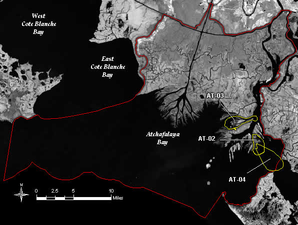
Major features in the basin include the Lower Atchafalaya River, Wax Lake Outlet,
Atchafalaya Bay, and the Atchafalaya River and Bayous Chene, Boeuf, and Black
navigation channel. Features of the Mississippi River and Tributaries (MR&T)
flood control system, including the Old River complex and the Atchafalaya Basin
Floodway system, define the flow and sediment resources entering the basin and
influence the basin's evolution.
Previous Mississippi River delta complexes, including the Sale-Cypremort and
the Teche deltas, formed the majority of the land within the Atchafalaya Basin.
Delta growth in Atchafalaya Bay is a recent occurrence, with subaqueous delta,
or land underwater, forming in the decade from 1952 to 1962 and subaerial delta,
or land above the water, forming during the 1973 flood. About 16,000 acres of
subaerial land exist today in the Lower Atchafalaya River and Wax Lake Outlet
deltas in Atchafalaya Bay.
The Atchafalaya Basin is unique among the basins because it has a growing
delta system with nearly stable wetlands. Wetland loss is minor in the areas
north of Atchafalaya Bay when compared to the other basins. The total wetland
loss in the area is approximately 3,760 acres between 1932 and 1990. The average
loss from 1974 through 1990 is 87 acres per year. Wetland loss in this area is
site dependent; loss is primarily due to erosion, human activities, and natural
conversion. Storms and hurricanes cause shoreline erosion between Wax Lake
Outlet and Point Chevreuil. Oil and gas pipelines disrupt the natural movement
of flow and sediment within the wetlands. The development of the Lower
Atchafalaya River, from a tidal to a riverine system, has created natural levees
along the banks of the river, disrupting the movement of flow and sediment into
the wetlands.
In Atchafalaya Bay, wetland gain, rather than loss, is taking place. However,
natural processes and human activity are limiting the effectiveness of flow and
sediment resources in creating new wetlands by affecting sediment delivery,
deposition, and retention. Winter storm fronts, waves, and currents refine and
reshape the deltas in the bay by eroding and reworking sediments. MR&T
project features such as the Wax Lake Outlet Control Structure affect the
location and quantity of flow and sediment entering the bay. Sediments available
for delta building in the Lower Atchafalaya River delta deposit in the channel
above Atchafalaya Bay. These sediments reach the delta only during significant
high water events. The Chene, Boeuf, and Black navigation channel affects
deposition and retention of sediments within the Lower Atchafalaya River delta.
The majority of sediments conveyed by the Lower Atchafalaya River do not reach
the delta; sands fall out in the navigation channel where they are dredged to
maintain navigation; silts and clays are conveyed out of the bay. The lack of
sediments available for delta growth in the Lower Atchafalaya River delta is
evident when the growth rate of this delta is compared to that of the Wax Lake
Outlet delta. The Wax Lake Outlet delta receives approximately one-third the
amount of flow and sediment of the Lower Atchafalaya River delta, and yet grows
at a rate three times as great.
Projects in the Atchafalaya Basin
Summary of the Basin Plan
STUDY AREA
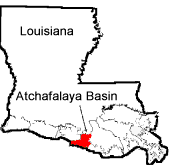
The Atchafalaya Basin is located in the central part of the coastal zone,
west of the Terrebonne Basin (Figure AT-1). It encompasses 58,400 acres of
wetlands in St. Mary Parish. The basin boundaries are the Mississippi River and
Tributaries (MR&T) system levees below Berwick and Calumet to the north,
Bayou Shaffer southward along the bank of the Lower Atchafalaya River to its
mouth then following the shoreline around Atchafalaya Bay to Point Au Fer to the
east, and a north-south line extending through Point Chevreuil to the west.
EXISTING CONDITIONS AND PROBLEMS
Major features in the basin include the Lower Atchafalaya River, Wax Lake
Outlet, Atchafalaya Bay, and the Atchafalaya River and Bayous Chene, Boeuf, and
Black navigation channel. Features of the Mississippi River and Tributaries
(MR&T) flood control system, including the Old River complex and the
Atchafalaya Basin Floodway system, define the flow and sediment resources
entering the basin and influence the basins evolution.
Previous Mississippi River delta complexes, including the Sale-Cypremort and
the Teche deltas, formed the majority of the land within the Atchafalaya Basin.
Delta growth in Atchafalaya Bay is a recent occurrence, with subaqueous delta,
or land underwater, forming in the decade from 1952 to 1962 and subaerial delta,
or land above the water, forming during the 1973 flood. About 16,000 acres of
subaerial land exist today in the Lower Atchafalaya River and Wax Lake Outlet
deltas in Atchafalaya Bay.
The Atchafalaya Basin is unique among the basins because it has a growing
delta system with nearly stable wetlands. Wetland loss is minor in the areas
north of Atchafalaya Bay when compared to the other basins. The total wetland
loss in the area is approximately 3,760 acres between 1932 and 1990. The average
loss from 1974 through 1990 is 87 acres per year. Wetland loss in this area is
site dependent; loss is primarily due to erosion, human activities, and natural
conversion. Storms and hurricanes cause shoreline erosion between Wax Lake
Outlet and Point Chevreuil. Oil and gas pipelines disrupt the natural movement
of flow and sediment within the wetlands. The development of the Lower
Atchafalaya River, from a tidal to a riverine system, has created natural levees
along the banks of the river, disrupting the movement of flow and sediment into
the wetlands.
In Atchafalaya Bay, wetland gain, rather than loss, is taking place. However,
natural processes and human activity are limiting the effectiveness of flow and
sediment resources in creating new wetlands by affecting sediment delivery,
deposition, and retention. Winter storm fronts, waves, and currents refine and
reshape the deltas in the bay by eroding and reworking sediments. MR&T
project features such as the Wax Lake Outlet Control Structure affect the
location and quantity of flow and sediment entering the bay. Sediments available
for delta building in the Lower Atchafalaya River delta deposit in the channel
above Atchafalaya Bay. These sediments reach the delta only during significant
high water events. The Chene, Boeuf, and Black navigation channel affects
deposition and retention of sediments within the Lower Atchafalaya River delta.
The majority of sediments conveyed by the Lower Atchafalaya River do not reach
the delta; sands fall out in the navigation channel where they are dredged to
maintain navigation;
silts and clays are conveyed out of the bay. The lack of sediments available
for delta growth in the Lower Atchafalaya River delta is evident when the growth
rate of this delta is compared to that of the Wax Lake Outlet delta. The Wax
Lake Outlet delta receives approximately one third the amount of flow and
sediment of the Lower Atchafalaya River delta, and yet grows at a rate three
times as great.
FUTURE WITHOUT-PROJECT CONDITIONS
Wetland loss in the area north of Atchafalaya Bay will generally continue at
historical rates, resulting in 4,350 acres lost in this area in 50 years, or 8
percent of the existing acreage. Periodic overflow from the Atchafalaya system
will continue to augment the wetlands, contributing to their overall stability.
However, as the Lower Atchafalaya River and the Wax Lake Outlet evolve into
riverine systems, natural levees will continue to form along the channel,
disrupting the flow of sediment into the wetlands.
The deltas in Atchafalaya Bay will continue to grow. In 50 years,
approximately 67,000 acres of subaerial delta will be present in both the Lower
Atchafalaya River and the Wax Lake Outlet deltas. Of this subaerial land,
approximately 27,550 acres will be vegetated wetlands--9,760 acres in the Lower
Atchafalaya River delta and 17,790 acres in the Wax Lake Outlet delta,
representing a gain in excess of 600 percent over the existing acreage.
As the deltas continue to grow, Atchafalaya Bay will change toward a riverine
environment. Changes in salinity, water temperature, and turbidity will reduce
shrimp, oyster, and marine fisheries production and increase furbearing,
waterfowl and freshwater species production.
Table AT-1 shows projected wetland gain in the Atchafalaya Basin.
Table AT-1
Projected Wetlands in the Atchafalaya Basin
Measured Loss Projected Gain Projected Gain
1932-1990 in 20 years in 50 years
(Acres) (Percent) (Acres) (Percent) (Acres) (Percent)
3,760 6.4 6,790 11.6 19,060 32.6
BASIN PLAN
Three strategies are available to increase the quantity of sediment delivered
to Atchafalaya Bay: realign the entrance to Wax Lake Outlet, modify the Lower
Atchafalaya River to increase its efficiency, and dredge sediments. Realigning
the entrance to the Wax Lake Outlet is the preferred strategy. It creates more
wetlands at a lower cost than the other two strategies.
Three strategies are available to reduce the quantity of sediment bypassing
the Lower Atchafalaya River delta: relocate the navigation channel; relocate the
flow and sediment to Wax Lake Outlet; and manage the growth of the Lower
Atchafalaya River delta (delta management). Relocating the navigation channel is
the preferred strategy because it solves a major problem of limited growth of
the Lower Atchafalaya River delta without creating flood problems in the
Teche/Vermilion Basin or significantly reducing flow and sediment to the
Terrebonne Basin. However, it has the potential for significant environmental
and engineering problems. Delta management, on the other hand, can be initiated
now and continue over the long term until these issues are resolved.
Delta management, relocating the navigation channel, and realigning the
entrance to Wax Lake Outlet are the selected large scale measures to reduce the
impact of human activity on the growth and development of wetlands in the
Atchafalaya Basin. Priority projects to reopen Natal Channel and Radcliffe Pass
and reduce the height of the Big Island in Atchafalaya Bay also reduce the
impact of human activity in the short-term. These projects work toward the
long-term goal of overall delta management. Other short-term measures support
the overall basin plan. Management in the established wetlands north of
Atchafalaya Bay by closing oil and gas pipelines and reopening closed
distributaries, restores fluvial input disrupted by human activity and natural
processes. Shoreline protection reduces erosion. Dredging sediments creates
wetlands that offset loss from human activity and natural processes.
Delta management is the critical component of the plan for the basin because
of its significant impact on delta growth. Reopening Natal Channel and Radcliffe
Pass and reducing the height of Big Island are critical to the success of the
restoration plan because they will shape the direction of future delta
management activities in the Lower Atchafalaya River delta. Results of delta
management will be enhanced in the long term with the relocation of the
navigation channel. This long-term effort will require engineering and
environmental studies to ensure a feasible plan.
The short-term portion of the plan contains projects that can be implemented
under the CWPPRA with minimum effort. Small scale projects such as shoreline
protection measures are effective in solving small, site dependent problems of
wetland loss and erosion and creating small areas of wetlands.
In summary, the selected plan uses sediment diversion, marsh creation, and
shoreline protection measures to achieve the basin objectives. The predominant
feature is sediment diversion. The selected plan emphasizes management of
existing resources until these resources can be increased in the future.
Nine individual projects are part of the selected plan for the Atchafalaya
Basin. Table AT-2 summarizes these projects, indicating project type, cost,
acres created, whether the project is critical or supporting, and if it is to be
implemented in the short term or long term. Appendix F contains a detailed
description of each project.
Appendix F contains a description of the plan formulation process. Figure
AT-2 shows the main elements of the plan.
COSTS AND BENEFITS
The selected plan creates, protects, and restores approximately 11,090 acres
of wetlands over 20 years and a total of 28,150 acres in 50 years. The three
critical projects create, protect, or restore 8,110 acres of wetlands over a 20
year period at a cost of $15,981,000. In addition, these projects benefit an
additional 5,960 acres. The critical long-term project, delta management,
creates an additional 4,070 acres of wetlands in 50 years. Short-term supporting
projects create, protect, or restore 350 acres of wetlands in 20 years at a cost
of $3,407,000 and benefit an additional 2,110 acres. Long-term supporting
projects create 15,630 acres in 50 years at a cost of $110,590,000.
Back to Top
Dynamics of the Basin
The Atchafalaya Basin is located in south-central Louisiana and is bounded by
the Mississippi River and Tributaries (MR&T) system levees. The basin
encompasses approximately 374,000 acres of fresh marsh, bottomland hardwoods,
cypress swamps, and open water. The basin contains the largest contiguous tract
of fresh marsh in the state, a valuable national resource. The Atchafalaya River
is the dominant feature within the basin.
The Atchafalaya River has served as a distributary of the Mississippi River
since the 1500s (van Heerden and Roberts 1980). Although most of the Mississippi
River's flow has been directed towards the modern Plaquemines-Belize delta,
river sediment was deposited throughout the Atchafalaya Basin and declined in
the 1950s, when most inland lakes and bays achieved a sediment-filled state.
Sediment deposition then began at the Gulf of Mexico in the Atchafalaya Bay,
resulting in an emergent delta in 1973. The Atchafalaya Delta has grown each
year since 1973 to its present size of 11.3 square miles.
The lower Atchafalaya River Navigation Channel bisects the Atchafalaya delta.
The USACE maintains the 20 foot by 400-foot channel to the Gulf of Mexico by
dredging approximately 11,100,000 cubic yards annually. Increased channel depth
has formed an efficient conduit for river sediment to the Gulf of Mexico,
depriving the adjacent delta environments of sediment critical to the
delta-building process. Some distributary channels in the basin have undergone a
reduction in carrying capacity due to USACE activities. The MR&T project -
the comprehensive flood control project for the lower Mississippi Alluvial
Valley below Cairo, Illinois - has had a significant impact on the water and
land resources in the Atchafalaya Basin. However, the USACE has also created
several hundred acres of marsh through judicious placement of dredged material
and encouragement of delta formation.
The Atchafalaya Basin contains the resources to allow for substantial land
building capacity. The flow rate of the river averages 226,760 cfs, with an
annual average sediment load of 88,223,000 tons. Two channels, the Wax Lake
Outlet and the Lower Atchafalaya River, convey flow and sediment to the
Atchafalaya Bay. The Wax Lake Outlet conveys 38% of this flow and 35% of the
suspended sediment. Two young, active deltas are forming in the Atchafalaya Bay
at the mouths of the Wax Lake Outlet and the Lower Atchafalaya River.
The Atchafalaya Basin is unique among Louisiana coastal basins because it has
a growing delta and nearly stable wetlands. Land loss has been centered around
direct conversion to open water due to construction of canals, subsidence, and
erosion. Riverine processes, which are the building blocks that create and
maintain wetlands, dominate the basin. Human activities such as navigation
interests and mineral exploration are the primary factors limiting delta growth
in the Atchafalaya Basin, as these activities limit the riverine processes.
Sediment accretion usually keeps pace with subsidence in this basin, enabling
the wetlands to remain relatively stable, healthy, and productive. However,
localized wetland loss takes place where riverine processes are limited and
during nonflood years when river stages are abnormally low. Human activity is
also shaping the evolution of the Atchafalaya Basin. The flood control features
of the MR&T project define the quantity and entry location of flow and
sediment into the Atchafalaya Basin. The Lower Atchafalaya navigation channel
conveys the majority of flow and sediment beyond the Lower Atchafalaya River
delta affecting delta growth. Oil and gas exploration creates canals through the
wetlands and the delta, disrupting natural sediment
Back to Top
Discussion
No projects have been completed in the Atchafalaya Basin; therefore, there
are no results of project performance. However, these projects are similar to
sediment diversions implemented in the Mississippi River Delta and results are
expected to be similar. The projects in the Mississippi River delta have proven
extremely successful in creating new wetlands and enhancing existing wetlands in
that basin. Riverine processes provide the essential components for wetland
creation and maintenance, and results obtained from projects in the Mississippi
Delta have proven that management of these riverine processes is the most
effective method of wetland creation available. Maintenance of navigation
channels in the Atchafalaya Basin has contributed to disruption of natural
riverine processes in the Atchafalaya Delta. However, as more knowledge is
obtained, maintenance dredging of the navigation channel is being conducted in
ways that restore natural riverine processes and thus enhance and create
wetlands.