
The Barataria Basin is an irregularly shaped area bounded on each side by a distributary ridge formed by
the present and a former channel of the Mississippi River. A chain of barrier
islands separates the basin from the Gulf of Mexico. In the northern half of the
basin, which is segregated by the Gulf Intracoastal Waterway (GIWW), several
large lakes occupy the sump position approximately half-way between the ridges.
The southern half of the basin consists of tidally influenced marshes connected
to a large bay system behind the barrier islands. The basin contains 152,120
acres of swamp, 173,320 acres of fresh marsh, 59,490 acres of intermediate
marsh, 102,720 acres of brackish marsh, and 133,600 acres of saline marsh.
Within the Barataria Basin, wetland loss rates averaged nearly 5,700 acres
per year between 1974 and 1990. During this period, the highest rates of loss
occurred in the Grande Cheniere and Bay Regions. Wetland loss within the
Barataria Basin is attributed to the combination of natural erosional processes
of sea-level rise, subsidence, winds, tides, currents, and herbivory, and the
human activities of channelization, levee construction, and development.
Freshwater and sediment input to the Barataria Basin was virtually eliminated
by the erection of flood protection levees along the Mississippi River and the
closure of Bayou Lafourche at Donaldsonville; therefore, the only significant
source of fresh water for the basin is rainfall. Only a small amount of riverine
input, designed to mimic a natural crevasse, is introduced into the basin's
wetlands through the recently completed siphons at Naomi and West Pointe a la
Hache. This lack of fresh water, and the loss of the accompanying sediments,
nutrients, and hydrologic influence, forms the most critical problem of the
Barataria Basin.
The second critical problem is the erosion of the barrier island chain. As
individual islands are reshaped or breached, or succumb to the forces of the
Gulf of Mexico, passes widen and deepen with the result that a greater volume of
water is exchanged during each tide.
Four islands-West Grand Terre, East Grand Terre, Grand Pierre, and Cheniere
Ronquille-had a combined area of just over 1,800 acres in 1990. By 2015, the
islands will be reduced to a total of approximately 1,000 acres. East Grand
Terre and Grand Pierre are predicted to disappear by 2045, and the remaining
islands will consist of only 400 acres.
The result of the problems described above is an increase in tidal amplitude
in the marshes in the central basin. This cumulative effect is exemplified by
increased salinities in the lower half of the basin, increased land loss rates,
and change in vegetation.
Site-specific problems of shoreline erosion, especially in areas with organic
soils, poor drainage, salinity stress, and herbivory, are apparent throughout
the basin. Solving these problems is important, but less urgent than solving the
critical problems described above.
Projects in the Barataria Basin
Summary of the Basin Plan
STUDY AREA
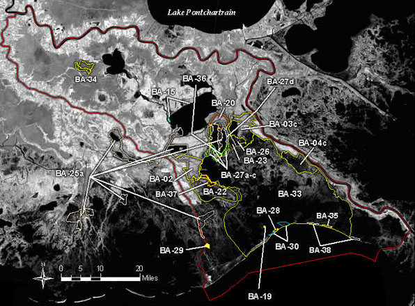
The Barataria Basin (Figure BA-1) is located immediately south and west of
New Orleans, Louisiana. The basin is bounded on the north and east by the
Mississippi River from Donaldsonville to Venice, on the south by the Gulf of
Mexico, and on the west by Bayou Lafourche. The basin contains approximately
1,565,000 acres. Portions of nine parishes are found in the basin: Assumption,
Ascension, St. James, Lafourche, St. John the Baptist, St. Charles, Jefferson,
Plaquemines, and Orleans. The basin is divided into nine subbasins: Fastlands,
Des Allemands, Salvador, Central Marsh, Grande Cheniere, L'Ours, North Bay, Bay,
and Empire.
EXISTING CONDITIONS AND PROBLEMS
The Barataria Basin is an irregularly shaped area bounded on each side by a
distributary ridge formed by the present and a former channel of the Mississippi
River. A chain of barrier islands separates the basin from the Gulf of Mexico.
In the northern half of the basin, which is segregated by the Gulf Intracoastal
Waterway (GIWW), several large lakes occupy the sump position approximately
half-way between the ridges. The southern half of the basin consists of tidally
influenced marshes connected to a large bay system behind the barrier islands.
The basin contains 152,120 acres of swamp, 173,320 acres of fresh marsh, 59,490
acres of intermediate marsh, 102,720 acres of brackish marsh, and 133,600 acres
of saline marsh.
Within the Barataria Basin, wetland loss rates averaged nearly 5,700 acres
per year between 1974 and 1990. During this period, the highest rates of loss
occurred in the Grande Cheniere and Bay Regions. Wetland loss within the
Barataria Basin is attributed to the combination of natural erosional processes
of sea-level rise, subsidence, winds, tides, currents, and herbivory, and the
human activities of channelization, levee construction, and development.
Freshwater and sediment input to the Barataria Basin was virtually eliminated
by the erection of flood protection levees along the Mississippi River and the
closure of Bayou Lafourche at Donaldsonville; therefore, the only significant
source of fresh water for the basin is rainfall. Only a small amount of riverine
input, designed to mimic a natural crevasse, is introduced into the basin's
wetlands through the recently completed siphons at Naomi and West Pointe a la
Hache. This lack of fresh water, and the loss of the accompanying sediments,
nutrients, and hydrologic influence, forms the most critical problem of the
Barataria Basin.
The second critical problem is the erosion of the barrier island chain. As
individual islands are reshaped or breached, or succumb to the forces of the
Gulf of Mexico, passes widen and deepen with the result that a greater volume of
water is exchanged during each tide.
Four islands-West Grand Terre, East Grand Terre, Grand Pierre, and Cheniere
Ronquille-had a combined area of just over 1,800 acres in 1990. By 2015, the
islands will be reduced to a total of approximately 1,000 acres. East Grand
Terre and Grand Pierre are predicted to disappear by 2045, and the remaining
islands will consist of only 400 acres.
The result of the problems described above is an increase in tidal amplitude
in the marshes in the central basin. This cumulative effect is exemplified by
increased salinities in the lower half of the basin, increased land loss rates,
and change in vegetation.
Site-specific problems of shoreline erosion, especially in areas with organic
soils, poor drainage, salinity stress, and herbivory, are apparent throughout
the basin. Solving these problems is important, but less urgent than solving the
critical problems described above.
FUTURE WITHOUT-PROJECT CONDITIONS
Projected wetland loss over the next 20 and 50 years within Barataria Basin,
by the subbasins, is shown in Table BA-1. Without actions to correct the
problems mentioned above, another fifth of the basin's wetlands would be lost to
open water by 2045. Roughly 65 percent of the projected wetland loss, or
more than 100,000 acres, would occur in the North Bay, L'Ours, Bay, and Empire
subbasins. As wetlands bordering Barataria Bay erode and as its connection with
the gulf becomes substantially larger because of the disappearance of the
barrier islands, the bay would enlarge, absorbing adjacent waterbodies. With no
action, moderate wetland losses (about 20 percent) would occur in the
middle of the basin (Central Marsh and Salvador subbasins), and relatively minor
losses (about 8 percent) would occur in the upper basin (Des Allemands)
over the next 50 years. The disappearance of wetlands throughout Barataria Basin
would mean the loss of critical breeding, nesting, nursery, foraging, or
overwintering habitat for economically important fish, shellfish, furbearers,
migratory waterfowl, alligator, and several endangered species. Loss of wetland
habitat and the accompanying trend toward higher salinities would lead to lower
biodiversity and productivity.
Table BA-1
Projected Marsh Loss in the Barataria Basin.
Projected Loss in 20 years Projected Loss in 50 years
Subbasin (Acres) (Percent) (Acres) (Percent)
Des Allemands 1,010 3 2,520 7
Salvador 4,610 4 11,540 11
Central 7,380 10 18,440 26
L'Ours 6,240 21 15,590 53
North Bay 10,160 12 25,390 31
Grand Chenier 6,510 44 14,660 100
Empire 17,460 58 30,110 100
Bay 22,790 28 56,980 70
Total 76,160 17 175,230 38
Projected losses are based on Geographic Information System data compiled by
the U.S. Army Corps of Engineers. Loss rates also are based on a projection of
the 1974 to 1990 rates.
The disappearance of wetlands and the wildlife and fishery resources
dependent on them would affect the economic structure of numerous communities in
the lower and middle basin areas as supporting businesses (marinas, boat
manufacturers, seafood processors, retailers, etc.) decline. In addition, the
storm buffering benefits the barrier islands and lower basin wetlands provide these
communities, would be reduced as wetland loss continues. This loss would force
relocations or require the expansion of flood protection and drainage facilities
for many basin communities, and maintenance costs would increase for existing
facilities.
BASIN PLAN
The selected plan focuses on the key strategies of freshwater and sediment
diversion, combined with outfall and hydrologic management to reduce tidal
exchange. Two additional mutually exclusive strategies were considered to offset
the increase in tidal amplitude: sediment replenishment of the existing barrier
islands or construction of a set of interior barrier islands. The former has
been included in the selected plan because it supports the natural system, and
would maintain the marshes located between the proposed interior barrier and the
existing barrier islands. Supporting strategies of marsh creation with dredged
material and shoreline protection address localized areas of marsh loss. A
detailed description of the plan formulation process is contained in Appendix D.
Strategies of the selected basin plan are shown in Figure BA-2, and projects are
listed in Table BA-2.
Restoration of riverine input into the basin via freshwater diversion from
the Mississippi River through the authorized Davis Pond Freshwater Diversion
project helps in solving the first critical problem of freshwater and sediment
deprivation. This diversion is vital to the health of the upper part of the
basin because fresh water and nutrients slow the loss of marsh and swamp.
Additional diversions from the Mississippi River on the eastern side of the
basin, and the reconnection of Bayou Lafourche and subsequent construction of
small diversions on the western side, are long-term solutions to the first
critical problem. However, a study of the sediment and water budget for the
Mississippi River must be completed first.
Sediment replenishment and marsh creation on the bay side of the barrier
islands will strengthen the buffering capabilities of the barrier chain.
Longshore sediment drift studies will determine the efficacy of installing
segmented breakwaters or jetties to trap sediments that are, at present,
transported from the system. Studies are planned on methods to reduce the cost
of construction and to better evaluate the benefits of barrier islands to
interior marshes. However, sediment replenishment of critical barrier islands
(located adjacent to major tidal passes) needs to be implemented in the short
term.
Hydrologic management to decrease tidal flux through the critical area of the
central marshes and LOurs Ridge will preserve the marshes in this area and
slow the inland progression of the marine influence. Methods to reduce marsh
loss rates and shoreline erosion, while providing access to the
estuarine-dependent marine organisms so important to the economy of this basin,
should be developed and implemented as soon as possible.
Several site-specific areas of loss are scattered throughout the basin.
Small-scale measures to preserve, restore, and enhance these marshes and swamps
are important. Implementation of these projects will maintain these areas until
the critical long-term projects are in place.
The selected plan uses a mix of measures to achieve short-term basin
objectives. Hydrologic restoration (77 percent), outfall management (8 percent),
and barrier island nourishment (6 percent) account for the majority of the
acres preserved, created, or enhanced. Marsh creation with dredged material,
shoreline protection, and marsh management complete the short-term restoration
process. The long-term portion of the plan, necessary to achieve no net loss of
wetlands, consists of additional freshwater and sediment diversions, and
continued barrier island replenishment.
COSTS AND BENEFITS
Table BA-3 summarizes the wetland benefits and costs over the next 20 years
for the short-term projects proposed in the Barataria Basin selected plan and
for the Davis Pond Freshwater Diversion project. The Davis Pond Freshwater
Diversion project will preserve 83,000 acres over 50 years at a cost of $68.8
million. However, to be comparable to the CWPPRA projects, benefits and costs
for 20 years (32,220 acres and $26,696,000) were used.
In the Des Allemands Subbasin, no direct benefits are achieved because there
are no selected plan short-term projects and Davis Pond Freshwater Diversion is
located south of the subbasin. However, this area will indirectly benefit from
plan implementation because significant portions of the seaward subbasins will
be restored or maintained, thus providing a continued barrier to the inland
progression of marine influence.
Implementation of the short-term projects in the Salvador Subbasin would
prevent 28 percent of the predicted loss. In the Central Marsh Subbasin,
implementation of already funded projects BA-2, PBA-35, and XBA-65A, plus the
deferred project BA-6, would result in predicted marsh enhancement of 177 percent.
When estimated Davis Pond Freshwater Diversion benefits are added to the
Salvador and Central Marsh Subbasins, marsh enhancement increases to 337 and 281 percent,
respectively. The CWPPRA costs are $39,889,000.
Plan implementation would prevent 12, 13 and 55 percent of the predicted
loss in the L'Ours, North Bay and Grande Cheniere Subbasins. The projects
located in this mid-basin area are designed to protect wetlands against tidal
and erosive forces. Adding the Davis Pond Freshwater Diversion benefits to the
North Bay Subbasin prevents 75 percent of the predicted loss. The CWPPRA
costs for this area are $8,344,000.
The lower basin marshes and barrier islands which make up the Empire and Bay
Subbasins are projected to undergo the greatest losses. Plan implementation
would only reduce the losses in these areas by 5 and 8 percent, respectively.
The Davis Pond Freshwater Diversion project would prevent the loss of an
additional 17 percent of wetlands in the Bay Subbasin. The CWPPRA costs are
$66,425,000.
For a total expenditure of $114,658,000 on the selected plan projects, 23,050
acres of wetlands will be created, restored or protected. Over the next 20
years, 30 percent of predicted loss in the entire Barataria Basin would be
prevented. Benefits from the Davis Pond Freshwater Diversion project increases
the predicted amount of marsh saved to 73 percent, including gains in two
subbasins.
Back to Top
Dynamics of the Basin
Located south and west of New Orleans, the Barataria Basin is bounded on the
north and east by the Mississippi River, on the west by Bayou Lafourche, and on
the south by the Gulf of Mexico (figure 21). The basin is approximately 120
miles long, with a width ranging from 24 to 35 miles. The basin contains
approximately 1,565,000 acres, of which 341,500 acres (22%) are leveed or
developed areas. The region contains major corridors of developed areas along
the Mississippi River and Bayou Lafourche. While most of the land is privately
owned, two wildlife management areas and one national park with a total of
65,000 acres are located within the basin.
Several natural and constructed physiographic features in Barataria Basin
influence habitat distribution, hydrology, land use, and wetland restoration
opportunities. Major features include natural and artificial levees of the
Mississippi River and Bayou Lafourche, the GIWW, U.S. Highway 90, the central
marsh landmass, the chenier complex, and a chain of barrier islands. The island
chain is eroding and will continue to deteriorate unless restorative measures
are implemented. The USACE maintains major navigation channels in the basin.
These include the Barataria Bay Waterway, which runs from Barataria Pass at
Grand Isle to the GIWW south of Lake Salvador; the GIWW, which runs east-west
through the central reaches of the basin; and the Empire-Gulf Waterway, which
runs from the gulf to the Mississippi River in southeast Barataria. All are
major navigation routes for the oil and gas industry, the sulphur industry, and
commercial and recreational fishing. Sediment deposited by the Mississippi River
in the former St. Bernard and Lafourche deltas filled the margins of the Gulf of
Mexico and built these marshes over the last several thousand years (Frazier
1967). These marshes received periodic inputs of sediment and fresh water from
the Mississippi River until the early 1900s but are now isolated from the river.
Although there is currently no river discharge into these marshes, extensive
non-saline marshes exist where water exchange with the gulf is restricted,
primarily because average rainfall (162 centimeters/year) exceeds average
evapotranspiration (102 centimeters/year) in southeast Louisiana (Newton 1972).
Water volumes and water levels in the basin are strongly influenced by tides,
winds, and precipitation. Tides of the northern gulf have a relatively small
range between high and low, measuring 1 foot in the gulf and 0.1 foot in the
upper basin (LCWCRTF 1993). Storm tides can account for more than half of the
daily water level fluctuations in the basin (Jarrett 1976, Levin 1990). Water
exchange within the basin is highly variable (Richie 1985, Richie and Penland
1989). The dominant water exchange route between the upper and lower basin is
through Little Lake, Bayou Perot, and Lake Salvador.
Since 1932, Bararataria Basin has lost almost 17% of its land area (Dunbar et
al. 1992). Recent annual wetland loss estimates in Barataria Basin range between
5,200 (Dunbar et al. 1992) and 7,100 (Barras et al. 1994) acres per year (figure
21). At this rate, Barataria Basin will lose up to 142,340 acres of land during
the next 20 years-a loss greater than that in any other basin in Louisiana's
coastal zone. The subsidence rate in the Barataria Basin, based on USACE tide
gage readings (1947-78) at Bayou Rigaud, Grand Isle, Louisiana, is 0.80
centimeters (0.03 inches)/year (Penland et al. 1989).
Without actions to correct the land loss and habitat degradation in the
Barataria Basin, another fifth of the basin's wetlands may be converted to open
water by the year 2045. Approximately 65% of wetland loss would be concentrated
in the southern half of the basin. The Barataria Bay would enlarge, absorbing
adjacent water bodies, and its connection with the Gulf would become
substantially larger as barrier islands disappear. As a result of continued
erosion of the barrier island chain, the tidal passes will enlarge and deepen,
reducing the potential hydrologic benefits of the islands to the basin.
Back to Top
Discussion
All of the restoration projects planned for the Barataria Basin support the objectives and
strategies outlined for the basin. Both outfall management projects support the strategy of
managing freshwater and sediment input and enhancing fringe marshes in the basin. Continued
emphasis on fresh water diversion from the Mississippi River is also of prime importance.
The potential seems to exist not only to stop wetland loss, but to build new marsh through
sediment and fresh water reintroduction into the Barataria Basin.