Figure 18. Bayou La Branche (PPO-10), Geographic Information Systems (GIS) analysis of preconstruction and postconstruction.
CWPPRA Restoration Status
Since enactment of CWPPRA, six annual priority project lists have been prepared, resulting in selection of 80 coastal restoration projects for implementation in Louisiana’s coastal zone to address marsh loss in each of the nine coastal hydrologic basins. Table 2 summarizes the benefits and costs of these projects in each of Louisiana’s nine coastal hydrologic basins. Of these projects, four are currently undergoing formal deauthorization after initial selection and 14 serve as small-scale demonstration projects that will ultimately provide useful information for design of future restoration projects. The remaining 62 projects are anticipated to directly offset coastal land loss by 73,687 acres during their 20-year life. The total fully funded cost of these CWPPRA projects is $226,759,067 over the next 20 years. The status of all of these projects is summarized in table 3. Only those CWPPRA projects authorized as of January 1997 (Priority Project Lists I-V) are included in the basin- specific project discussion portions of this document. The CWPPRA Sixth Priority Project List (PPL VI), which includes projects throughout Louisiana’s coastal zone (figure 13), was approved April 24, 1997. Therefore, project-specific details on PPL VI are not included in the following basin discussions.
TABLE 2 - Summary of benefits and costs associated with CWPPRA restoration projects.
The following sections provide detailed summaries of anticipated benefits and preliminary monitoring results (when available) of the coastal restoration projects (Priority Project Lists I-V) funded by CWPPRA for each general coastal region (i.e., active deltas, inactive deltaic plain, and chenier plain) and corresponding basins. The goal of these summaries is to provide a holistic view of each coastal region’s problems and the restoration efforts undertaken to address them. For each basin, projects are discussed in the context of the restoration objectives to which they contribute so they can be better understood as an integrated network of restoration projects that, in concert, will move CWPPRA towards its regional objectives.
Combined, the Mississippi and Red rivers drain about 1,327,850 square miles of the United States (41%) and convey an enormous amount of sediment and freshwater to coastal Louisiana. The Mississippi River has two primary exit points along coastal Louisiana: the modern Mississippi River Delta (Plaquemines-Balize) in southeast Louisiana, and the growing Atchafalaya and Wax Lake deltas in south central Louisiana. These are the only two active delta basins in Louisiana’s coastal zone (figure 1).
The following discussion summarizes CWPPRA contributions to the restoration objectives of the Mississippi River Delta and the Atchafalaya River basins. While the specific needs of each basin differ slightly, both involve (1) maximization of existing freshwater, sediment and nutrient inputs and (2) introduction of additional large-scale fluvial inputs.
Mississippi River Delta Basin
Restoration Objectives
Restoration of the Mississippi River Delta Basin (Figure 14) will emphasize the more effective use and distribution of sediment transported by the Mississippi River. The goal for this basin is to distribute the flows of freshwater and sediment from the river for the purpose of creating and sustaining wetlands (table 4).
TABLE 4 - CWPPRA Restoration Projects in the Mississippi River Delta Basin.
CWPPRA Projects in the Mississippi
River Delta Basin
Utilizing the potential of the Mississippi River’s water and sediment flow, the principal restoration tool to be used in the basin is the construction of uncontrolled sediment diversions. This type of project mimics the natural process of crevasse-splay formation that occurs when the river or distributary pass breaches its levee during a high-water period and creates a splay of sediment in place of a shallow open-water area. As of January 1997, all sediment diversions implemented in the delta have been on a small scale and located on distributary passes only. However, the long-term objective for the basin includes large-scale diversions of unprecedented size to occur off the main Mississippi River channel. Constructed crevasses are presently in wide use throughout the delta, by both state and federal agencies, as the primary tool for creating new marsh in place of deteriorated areas. The monitoring elements, for those projects with Monitoring Plans completed by January 1997, and anticipated benefits and costs of CWPPRA projects in the Mississippi River Delta Basin are summarized in tables 5 and 6.
River diversion projects selected for CWPPRA priority lists include West Bay Sediment Delivery (FMR-3), Channel Armor Gap Crevasse (XMR-10) and Pass-a-Loutre Crevasse (MR-8/9). These three diversions are all to be located on the main Mississippi River channel and will be larger than other crevasses constructed previously in the delta. The West Bay Sediment Delivery (FMR-3) project is the largest of the three projects. The cumulative benefits of these three uncontrolled river diversions are expected to be the creation, restoration and protection of approximately 11,810 acres of new marsh over a 20-year period. A second type of project to be implemented for restoration of the delta is the utilization of dredged material to create marsh. The beneficial use of dredged material has been adopted by the USACE since 1973 and has proven to be an effective method for both the disposal of dredged material and the creation of wetlands. One CWPPRA demonstration project of this type, Beneficial Use of Hopper Dredge Material Demonstration (XMR-12), was selected on the fourth CWPPRA priority list. Currently, dredged material is disposed in one of the delta’s passes or in the deep waters of the gulf. This project will study the beneficial use of this material in shallow open-water areas. If this project is determined successful it is expected to contribute to the basin’s objective of expanding and stabilizing the existing delta.
While none of the larger scale CWPPRA diversion projects have yet been implemented, results from 13 small-scale state-funded diversion projects clearly illustrate the success of this type of project in creating new wetlands. As of January 1996, the 13 crevasses have cumulatively produced 313 acres of new land in place of open-water areas. The older crevasses (four to 10 years old) are producing land at an average annual rate of 10 to 28 acres/year while the younger crevasses (less than two years old) have rates of 0.2 to five acres/year (Kelley 1996). Figure 15 illustrates crevasse-splay formation over time for a small-scale crevasse created along Pass-a-Loutre. The crevasse, constructed in 1987, resulted in the formation of 103 acres of new marsh by 1996. As these projects continue to grow over time, analysis of monitoring results should enable us to make useful recommendations on the placement of future CWPPRA sediment diversion projects.
Atchafalaya River Delta Basin
Restoration Objectives
In the Atchafalaya River Delta Basin (figure 16), the primary restoration objective is to restore fluvial input in areas where flow and sediment have been disrupted and enhance the natural growth of the deltas and their evolution to wetlands (table 7). This approach addresses the principal causes of coastal wetland problems in the basin, which are a reduction in sediment input and a decrease in the retention of sediment within Atchafalaya Bay. An additional restoration objective is to reduce shoreline erosion of interior marsh.
TABLE 7 - CWPPRA Restoration Projects in the Atchafalaya River Delta Basin.CWPPRA Projects in the Atchafalaya River
Delta Basin
The projects selected in the Atchafalaya River Delta Basin Plan will help achieve the objectives described above. The monitoring elements for those projects with monitoring plans completed by January 1997 and anticipated benefits and costs associated with these projects are summarized in tables 8 and 9.
TABLE 9 - Anticipated Benefits and Costs of CWPPRA Restoration Projects in the Atchafalaya River Delta Basin.The two CWPPRA projects selected in this basin will reintroduce sediment and freshwater to delta environments that have been isolated from the Atchafalaya River. The Atchafalaya Sediment Delivery (PAT-2) project will reopen two distributary channels, thereby restoring delivery of freshwater and sediment. The dredged material will be used to create new wetland areas. The Big Island Mining (XAT-7) project will create a new distributary channel to deliver freshwater and sediment to an area that was isolated by deposition of dredged material associated with maintenance dredging of the Lower Atchafalaya Navigation Channel. The dredged material obtained from creation of the distributary channel will be used to create new wetlands. Both projects will encourage natural delta formation by re-establishing riverine flows to areas that are presently sediment-deprived. These projects are similar to sediment diversions implemented in the Mississippi River Delta and results are expected to be similar.
Four hydrologic basins make up the inactive deltaic plain of Louisiana’s coastal zone. These basins are the Pontchartrain, Breton Sound, Barataria and Terrebonne basins of southeast Louisiana. As remnants of former Mississippi River delta lobes, these basins flank the current Mississippi River route to the gulf with Pontchartrain and Breton Sound on the east and Barataria and Terrebonne on the west. The natural deterioration of these basins (after delta abandonment), combined with exploration, navigation and flood control activities, has resulted in a current wetland loss rate of up to 15,000 acres per year in the inactive deltaic plain.
The primary causes of wetland loss in the inactive deltaic plain are the interrelated effects of subsidence, sea level rise, erosion, sediment deprivation, saltwater intrusion and human activities. The most significant human activity causing wetland loss is the construction of the Mississippi River levees, which eliminated fluvial processes that nourished wetlands with freshwater and sediment. Other significant human activities include the construction of navigation channels and mineral exploration canals, breaching of natural ridges and the filling, draining, flooding or dredging of wetlands for various purposes. Because disruption of seasonal fluvial inputs is a common problem associated with each of these basins, reintroductions of these inputs where feasible are critical for the long-term restoration of each basin.
Pontchartrain Basin Restoration Objectives
Critical problems in the Pontchartrain Basin include (1) increased salinity and reduced sediment and nutrient input, (2) MRGO bank erosion, (3) possible loss of the land bridges and (4) areas where marsh loss is imminent, such as shoreline breaching. Less critical problems facing the Pontchartrain Basin include ponding or impoundment of water and nutria herbivory in the upper basin (near Lake Maurepas), shoreline erosion along the fringes of Lake Pontchartrain and the saline marshes in St. Bernard Parish, and poor water quality in Lake Pontchartrain. Pontchartrain Basin CWPPRA project boundaries and wetland loss/gain trends are presented in figure 17. The objectives identified for the Pontchartrain Basin include (table 10):
CWPPRA Projects in the Pontchartrain Basin
A total of nine CWPPRA projects have been approved to address the Pontchartrain Basin’s restoration objectives (table 10). The monitoring parameters for those projects with Monitoring Plans completed by January 1997 and anticipated benefits and costs for these projects are summarized in tables 11 and 12.
TABLE 11 - Monitoring Elements Collected for CWPPRA Restoration Projects in the Pontchartrain Basin.
TABLE 12 - Anticipated Benefits and Costs of CWPPRA Restoration Projects in the Pontchartrain Basin.
Two CWPPRA projects have been selected to address imminent loss caused by alterations to the natural hydrology. These projects, the MRGO Back Dike Marsh Protection (XPO-71) and Fritchie Marsh (PO-6) projects, involve hydrologic modifications that will result in conditions conducive to a productive fresh marsh. Construction on both of these projects is planned for 1997.
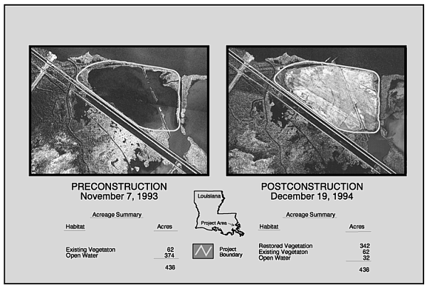
Three CWPPRA projects designed to create marsh through the use of dredged material include the Bayou La Branche (PPO-10) project, the Marsh Creation at Bayou Chevee (XPO-69) project and the Red Mud Coastal Restoration Demonstration (XTE-43) project. The Bayou La Branche project involved the infilling of an open-water area with dredged material from Lake Pontchartrain and was constructed in 1994. This project has created 342 acres of new marsh and protects 436 acres of intermediate/brackish marsh from the influences of Lake Pontchartrain (Carriere 1996a)(Figure 18). The Bayou Chevee marsh area is located in the Bayou Sauvage National Wildlife Refuge where dredged material from Lake Pontchartrain will be pumped, creating approximately 200 acres of marsh. The Red Mud Demonstration project, a collaborative effort with Kaiser Aluminum, will determine whether red mud (waste material from aluminum extraction) can be utilized as an alternative marsh creation material in combination with other materials such as compost and marsh sediment, without detriment to existing resources.
|
|
Figure 18. Bayou La Branche (PPO-10), Geographic Information Systems (GIS) analysis of preconstruction and postconstruction. |
The Violet Freshwater Distribution (PO-9A) project was designed to address the objective of introducing and managing freshwater in the basin. Constructed in 1992, the Violet Siphon Diversion was implemented by the state to prevent saltwater intrusion in its outfall. Preliminary data indicate that the freshwater introduced into the wetlands is having a positive effect in the immediate outfall area; however, due to a lack of outfall management, the freshwater quickly exits the project area and benefits are minimal (Carriere 1996b). The CWPPRA Violet Freshwater Distribution (PO-9A) project will more effectively manage the freshwater diverted from the Mississippi River and extend the benefits of this diversion to a larger area of marsh.
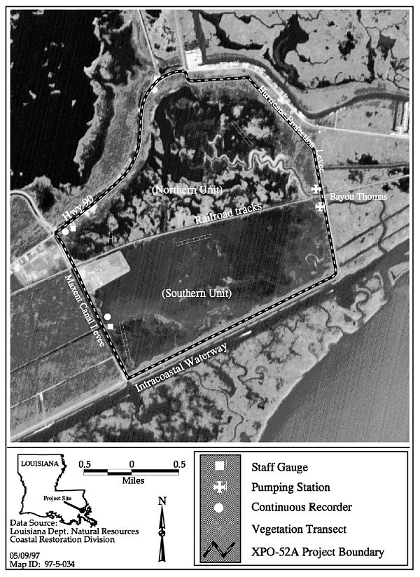
Two projects address marsh protection in local areas: the Bayou Sauvage Refuge Phase I and II (XPO-52A and B) projects. These two projects are designed to reduce excessive water levels caused by a hurricane protection levee and inadequate drainage through that levee.
More detailed summaries of completed projects in the Pontchartrain Basin (Bayou La Branche and Bayou Sauvage Refuge Phase I) follow.
|
|
Figure 19. Project Boundary and features for Bayou Sauvage Refuge Phase 1 (XPO-52A) (adapted from Holbrook 1996a) |
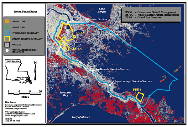
Breton Sound Basin Restoration Objectives
Breton Sound Basin (figure 20) restoration objectives entail improved management of existing freshwater and sediment inputs in the basin. Restoration objectives include (1) managing existing Mississippi River outfall to increase sediment deposition and (2) increasing overbank flow from the Mississippi River to nourish wetlands and reduce saltwater inflows (table 13).
TABLE 13 - CWPPRA Restoration Projects in the Breton Sound Basin.CWPPRA Projects in the Breton Sound Basin
As of January 1997, all projects selected for priority lists in the Breton Sound Basin address the restoration objectives outlined above. Three projects have been approved on the first five CWPPRA priority lists (table 13). Monitoring Plans for these projects have been initiated, but not completed; therefore a monitoring elements table is not included in this basin discussion. The anticipated benefits and costs of these projects are summarized in table 14.
TABLE 14 - Anticipated Benefits and Costs of CWPPRA Restoration Projects in the Breton Sound Basin.Two outfall management projects in the Breton Sound Basin include the Caernarvon Outfall Management (BS-3A) and the White’s Ditch Outfall Management (BS-4A) projects. The Caernarvon freshwater diversion structure began operating in 1991 and can deliver flows exceeding 8,000 cubic feet per second (cfs). Management of the Caernarvon outfall would route freshwater through the marshes and provide greater deposition of sediment to offset subsidence, allow greater use of nutrients by vegetation and provide a more gradual release of freshwater. Due to ongoing land rights conflicts, this project is currently being considered for de-authorization. The White’s Ditch Diversion has a current capacity of 250 cfs and has been operating since 1975 to create marsh, reduce salinity and enhance woodland habitat. In 1990 it added approximately 92 million cubic yards of freshwater and 13,000 tons of riverine sediment to Breton Sound Basin (Roberts et al. 1991). Outfall management of White’s Ditch includes enlargement of constricting lateral channels and installation of structures to reduce rapid outflow, both of which will encourage sediment deposition, freshwater overflow, and nutrient retention in the marsh.
|
|
Figure 20. Breton Sound Basin CWPPRA project boundaries and historical wetland loss/gain areas. |
An uncontrolled diversion project selected for implementation is the Grand Bay Crevasse (PBS-6) project. The Grand Bay and the adjacent marshes experienced significant freshwater and sediment input with annual Mississippi River flooding until a canal was partially filled along the riverbank. Enlargement of a rock-lined opening in the existing canal will reestablish a pathway for freshwater and sediment into Grand Bay. Ultimately, sediment from the Mississippi River will create a delta splay in Grand Bay upon completion of this project. Due to ongoing land rights conflicts, this project is currently being considered for deauthorization.
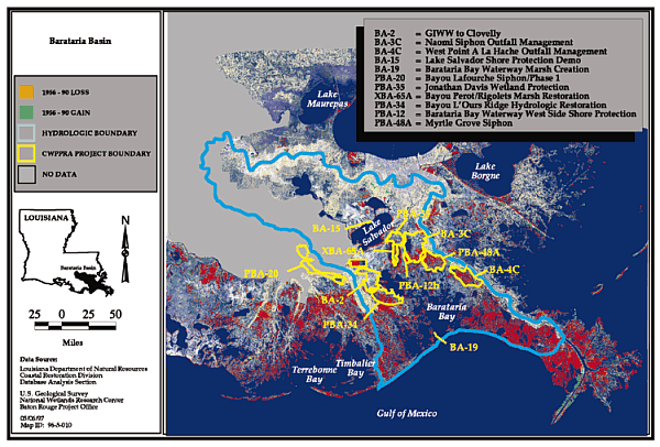
Barataria Basin Restoration Objectives
The proximity of the Mississippi River provides an opportunity to create new wetlands to offset regional losses experienced in the Barataria Basin (figure 21). Because of complex sediment dynamics in the Mississippi River, results obtained from the Mississippi River Sediment, Nutrient and Freshwater Redistribution Feasibility Study will be used to evaluate these wetland creation opportunities for this area.
|
|
Figure 21. Barataria Basin CWPPRA project boundaries and historical wetland loss/gain areas. |
Restoration objectives for the Barataria Basin include:
CWPPRA Projects in the Barataria Basin
A total of 12 CWPPRA projects have been approved to address the Barataria Basin’s restoration objectives (table 15). The monitoring elements for those projects with Monitoring Plans completed by January 1997 and anticipated benefits and costs for these projects are summarized in tables 16 and 17.
TABLE 15 - CWPPRA Restoration Projects in the Barataria Basin
TABLE 16 - Monitoring Elements Collected for CWPPRA Restoration Projects in the Barataria Basin.
TABLE 17 - Anticipated Benefits and Costs of CWPPRA Restoration Projects in the Barataria Basin.Two outfall management projects in the Barataria Basin are the Naomi (BA-3C) and West Pointe A La Hache (BA-4C) Outfall Management projects. The Naomi (LaReussite) and West Pointe a la Hache freshwater diversion siphons have been operational since early 1993 and divert sediment and nutrient-laden freshwater from the west bank of Mississippi River into the surrounding marshes of Plaquemines Parish. Both siphons are capable of diverting 2,144 cfs of freshwater that will reduce current marsh loss by adding sediment and nutrients and reducing the negative effects of saltwater intrusion. Both structures have effectively reduced mean project-area salinities (Haywood 1996a, Haywood 1996b). It is too early to quantify effects that the siphons are having on the vegetation communities in the project areas.
Unfortunately, a portion of the freshwater entering the respective project areas is flowing rapidly out of the areas, through local canals. This is a serious problem that the two CWPPRA outfall management projects will address. Both outfall management projects will promote freshwater and sediment retention in the project areas by using water control structures (i.e., earthen plugs and weirs) on major canals and bayous. The West Pointe A La Hache Outfall Management (BA-4C) project encompasses 16,912 acres of intermediate and brackish marsh. The Naomi Outfall Management (BA-3C) project area is 26,603 acres of fresh-to-brackish marsh.
Two siphon projects recently selected on the CWPPRA fifth priority list include the Bayou Lafourche Siphon Phase I (PBA-20) and the Myrtle Grove Siphon (PBA-48A). The Bayou Lafourche Siphon Phase I (PBA-20) project, sponsored by the EPA, was approved by the CWPPRA Task Force in February 1996 for preliminary engineering and design. If the project is approved for construction, it will be able to divert 2,000 cfs of freshwater into Bayou Lafourche, which has had an average flow of 260 cfs from the Mississippi River since 1904. This project may improve hydrology in central and fringing marshes and counteract subsidence by introducing freshwater, sediment and nutrients. Engineering investigations associated with this project will help determine potential impacts of siphon operation to unprotected developed areas along Bayou Lafourche, thereby determining if a need exists to continue into a next phase. The Myrtle Grove Siphon (PBA-48A) project is in the advanced engineering phase of design and will operate at a maximum discharge of 2,100 cfs. Discharge will nourish 15,894 acres of brackish marsh and open water near the community of Myrtle Grove in Plaquemines Parish by reintroducing sediment, nutrients and freshwater.
Six additional restoration projects, involving hydrologic restoration, marsh creation or shoreline protection, have been selected as of January 1997 in the Barataria Basin. The GIWW to Clovelly (BA-2) project area encompasses approximately 15,000 acres in Lafourche Parish and consists of shoreline protection, water-control structures, and the outfall management of freshwater from pumping stations. This project should restore the hydrology of the marshes south of Lake Salvador, west of Little Lake, and east of the communities of Larose and Cut Off.
The Jonathan Davis Wetland Protection (PBA-35) project encompasses 4,000 acres of intermediate marsh in Jefferson Parish and should reduce marsh loss rates by reducing shoreline erosion, tidal scour and saltwater intrusion. Bayou L’Ours Ridge Hydrologic Restoration (PBA-34) would serve to increase freshwater and sediment retention in 8,000 acres of open water and brackish marsh in Lafourche Parish. Bayou L’Ours was historically a tributary of Bayou Lafourche and at one time it carried Mississippi River water. The distributary ridge has been breached at numerous locations, thereby exposing the marshes north of the ridge to increased saltwater intrusion. The reestablished ridge should help retain freshwater from the existing forced drainage outfalls.
A marsh creation project in the Barataria Basin is the Barataria Bay Waterway Marsh Creation (BA-19) project. This project will utilize dredged sediment from the Barataria Bay Waterway to expand Queen Bess Island, in Barataria Bay, by nine acres. The island is one of only three nesting areas for the brown pelican in Louisiana.
Another CWPPRA restoration project along the Barataria Bay Waterway is the Barataria Bay Waterway West Side Shore Protection (PBA-12) project. The banks of Dupre Cut-Off Canal, located in Jefferson Parish, have deteriorated because of erosion from vessel wakes. Large breaches in the banks have resulted in increased water exchange and rapid salinity fluctuations within the adjacent marsh. The shoreline protection project’s objective is to rebuild the west bank of the Dupre Cut-Off Canal and protect adjacent marsh. The project encompasses 3,000 acres of brackish marsh and open-water habitat. A demonstration project addressing the problem of shoreline erosion in areas with unconsolidated or deep, soft mud bottoms is the Lake Salvador Shore Protection Demonstration (BA-15) project. This project encompasses approximately 1,000 acres in St. Charles Parish and is testing nontraditional structures for shoreline protection of regions with soils unsuitable for load bearing. For this project, four separate types of segmented breakwater structures will be placed in shallow water approximately 500 feet from shore, in an area that is currently experiencing an average shoreline erosion rate of 13 feet/year. The Lake Salvador Shore Protection Demonstration (BA-15) project is expected to yield valuable data on the relative effectiveness of various breakwaters in protecting marsh shorelines.
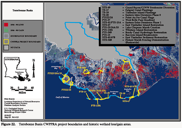
Terrebonne Basin Restoration Objectives
Based on recognition of the major causes of wetland problems in the Terrebonne Basin, CWPPRA projects (figure 22) have the following objectives:
|
|
Figure 22. Terrebonne Basin CWPPRA project boundaries and historical wetland loss/gain areas. |
CWPPRA Projects in the Terrebonne Basin
Fourteen CWPPRA projects have been approved from priority lists 1-5 for implementation in the Terrebonne Basin (Table 18). The monitoring elements for those projects with Monitoring Plans completed by January 1997 and anticipated benefits and costs for these projects are summarized in tables 19 and 20.
TABLE 18 - CWPPRA Restoration Projects in the Terrebonne Basin.
TABLE 19 - Monitoring Elements Collected for CWPPRA Restoration Projects in the Terrebonne Basin.
TABLE 20 - Anticipated Benefits and Costs of CWPPRA Restoration Projects in the Terrebonne Basin.The only project in Terrebonne basin approved as of January 1997 with the objective of restoring fluvial inputs is the Grand Bayou/GIWW Freshwater Diversion (XTE-49) project. Encompassing 26,530 acres of intermediate-to-brackish marsh and water, this project is designed to maintain emergent wetlands in the area by providing supplemental freshwater, nutrients and mineral sediment from the Atchafalaya River via the GIWW. The increased freshwater retention and decreased saltwater intrusion associated with this project are anticipated to provide benefits to emergent wetlands, wildlife and fisheries.
Barrier island restoration has been identified as critical to the Terrebonne Basin because of the potential for barrier islands to protect interior marshes. As of January 1997, six barrier-island restoration projects have been selected on CWPPRA priority lists. Four of these projects focus on restoration of Isles Dernieres and two focus on the Timbalier Island chain.
The first project on Isles Dernieres, the Eastern Isles Dernieres Phase 0 (TE-20) barrier island restoration project, was selected on CWPPRA’s first priority list. When completed, this project will restore and elevate the coastal dunes and construct and enhance the wetlands of the East Island, enhance the physical integrity of the island, and protect the lower Terrebonne estuary and associated vegetated wetlands against direct exposure to the Gulf of Mexico. A second barrier island project, the Eastern Isles Dernieres Phase 1 (XTE-41/PTE-15A) project, was selected on the second CWPPRA priority list and will restore East and Trinity islands by restoring dunes and wetlands through the use of dredged material, and maintain protection of Timbalier marshes. The third project on Isles Dernieres is the Whiskey Island Restoration (PTE-15Bi) project. Through construction of back-island marsh, this project is anticipated to protect bay areas from direct wave attacks from the Gulf of Mexico. The fourth barrier island project on Isles Dernieres is the Raccoon Island Breakwaters Demonstration (PTE-15) project. This is a demonstration project that will protect and stabilize Raccoon Island (the westernmost barrier island in the Isles Dernieres chain) through installation of eight segmented limestone breakwaters.
Two CWPPRA projects selected as of January 1997 will help restore East Timbalier Island: East Timbalier Island Restoration (XTE-67) and East Timbalier Sediment Restoration (XTE-45/67B). The East Timbalier Island Restoration (XTE-67) project was selected on the third CWPPRA priority list and will place 890,000 cubic yards of dredged material along the landward shoreline, prolonging the island’s ability to protect inland marsh. The East Timbalier Sediment Restoration (XTE-45/67B) project was selected on the fourth priority list. This project will fortify the rock breakwater fronting the island and re-create the central portion of the island (currently shallow water) through the use of dredged material. It will enhance the physical integrity of the island and prolong its potential protection of lower Terrebonne and Timbalier bays and associated wetlands.
|
|
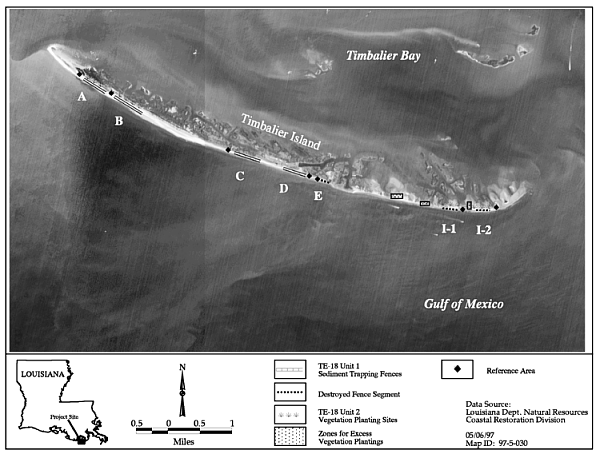
Figure 23. Timbalier Island Plantings (TE-18) project elements (adapted from Townson 1996). |
Hydrologic restoration projects are essential to areas where access and navigation canals have been constructed. The Brady Canal Hydrologic Restoration (PTE-26B) project was selected on CWPPRA’s second priority list and will maintain fresh and brackish marshes by enhancing freshwater, sediment and nutrient delivery into a fragile, highly fragmented transitional area between fresh and estuarine zones. The Lake Chapeau Marsh Creation (PTE-23/26A/33) project was selected on CWPPRA’s third priority list and will restore hydrology that has been altered by a network of canals on Point au Fer Island and reduce tidal fluctuations within the project area.
Two vegetative planting projects selected on the first CWPPRA priority list include Falgout Canal Plantings Demonstration (TE-17) and Timbalier Island Plantings Demonstration (TE-18). The Falgout Canal Plantings Demonstration (TE-17) is a demonstration project that will investigate the use of vegetative plantings and wave-damping devices to protect the northern bank of Falgout Canal from erosion caused by boat wakes. The Timbalier Island Plantings Demonstration (TE-18) project will minimize coastal erosion, restore vegetation zones and help maintain the integrity of the barrier island. Plantings were completed for this project in 1996.
A localized CWPPRA project utilizing dredged material is the West Belle Pass Headland (PTE-27) project. This project is on the second priority list and will utilize material dredged from Bayou Lafourche to build marsh and incorporate water control structures to reduce tidal influence and provide shoreline protection in the project area.
Another localized project from CWPPRA’s second priority list is the Point au Fer Canal Plugs (PTE-22/24) project. This project is anticipated to restore the hydrology of Point au Fer Island using water control structures and will build marsh using dredged material to backfill canals. This project is sponsored by NMFS, and construction of one phase was completed in March 1996.
A demonstration project selected on CWPPRA’s fourth list, the Flotant Marsh Fencing Demonstration (XTE-54B) project, will provide valuable information for future projects designed to protect the unique and fragile flotant marshes in the northwestern section of Terrebonne Basin. Because the organic nature of these soils often prohibits the restoration of hydrologic conditions by conventional methods (e.g., bank stabilization), alternative methods of restoration and protection are needed.
A more detailed summary of the first completed project in the Terrebonne Basin, the Timablier Island Plantings Demonstration (TE-18) project, follows.
Teche/Vermilion Basin Restoration Objectives
Few opportunities exist in the Teche/Vermilion Basin (figure 25) for wetland creation projects. However, the basin is well suited for wetland protection projects due to its stable nature and relatively low land loss rates. In order to successfully protect, restore and enhance the basin’s wetlands, several restoration objectives were established by the CWPPRA Task Force (table 21).
TABLE 21 - CWPPRA Restoration Projects in the Teche/Vermilion BasinThe first objective is to maximize the flooding of marshes with fresh, sediment-rich water from the Atchafalaya River, where available. This will introduce mineral nutrients, which often promote plant growth. Vigorous plant growth helps bind existing soils and creates new soil on the existing marsh surface, which counters the low subsidence and sea level rise in the low-energy environments associated with the chenier plain (Nyman et al. 1993). The second objective is to protect critical shorelines. Critical shorelines are those that are eroding rapidly or that form natural barriers between interior marsh ponds and dynamic water bodies such as bays and navigation channels that often allow introduction of excessive salt-laden water. A third objective is to slow, stop or reverse marsh loss in "hot spots." "Hot spots" should be addressed as quickly as possible because it will generally be more expensive to restore lost marsh than to protect existing marsh. Other objectives include the reduction or elimination of the moderate but widespread shoreline erosion problems in the basin and the creation of marsh where feasible.
CWPPRA Projects in the Teche/Vermilion Basin
Implementing appropriate projects will address the overall objectives of protecting, restoring and enhancing the basin’s marshes. The basin’s restoration objectives are being addressed through various CWPPRA projects involving shoreline protection, hydrologic restoration and sediment-trapping techniques. Monitoring elements for those projects with Monitoring Plans completed by January 1997 and anticipated benefits and costs associated with these projects are summarized in tables 22 and 23.
TABLE 23 - Anticipated Benefits and Costs of CWPPRA Restoration Projects in the Teche/Vermilion Basin.The marsh creation and enhancement potential of the sediment- and nutrient-laden Atchafalaya River water available to the basin must be maximized. An innovative restoration technique aimed at utilizing this riverine input is the placement of dredged-material terraces in shallow, open-water areas to act as wave-damping structures. The Little Vermilion Bay Sediment Trapping (PTV-19) project will utilize these created terraces to reduce wave energies in the bay, thereby allowing sediment and nutrients from the Atchafalaya River, via the GIWW, to settle and enhance submerged and emergent marsh vegetation growth. Additionally, marsh vegetation will be planted at the base of the created terraces to help bind the newly placed material and create marsh. This innovative marsh creation technique could be used in other areas to trap available sediment and nutrients where shallow, open water exists adjacent to high-energy environments.
|
|
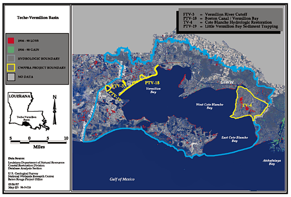
Teche/Vermillion Basin CWPPRA project boundaries and historical wetland loss/gain areas. |
Currently, areas of critical shoreline break up and retreat are the focus of CWPPRA projects employing shoreline protection structures. In the Cote Blanche Hydrologic Restoration (TV-4) project, a 10,000-foot marsh-level rock bulkhead along East Cote Blanche Bay will be constructed in an area experiencing rapid shoreline erosion. Since the marsh adjacent to the bulkhead location is being converted to open water through extreme fluctuations in water level and wave-generated erosion, several water-control structures will be used in the project to try to reduce the water fluctuations and subsequent loss of organic sediment from the project area’s interior. The combination of shoreline protection, addressing critical shoreline breakup and retreat and water-control structures should lead to the success of this project in protecting existing marsh.
The Vermilion River Cutoff (FTV-3) project was designed to protect the east side of the cutoff (on the northern shore of Vermilion Bay) from further erosion through the construction of an 8,900-foot breakwater adjacent to the bank, thereby preserving the inherent functions and values of approximately 2,000 acres in the Onion Lake Wetland Complex. The project, which was completed in February 1996, satisfies the basin’s objective of maintaining a barrier between the high-energy environment of the Vermilion River Cutoff and the fragile adjacent interior marshes. Currently only baseline elevations and aerial photography have been taken for this project. Assessments of project performance will be made when subsequent postconstruction elevations and photography are taken in 1998 and 1999, respectively. Although no assessments of performance are available at this time, results from the Boston Canal/Vermilion Bay (PTV-18) project (described on page 52) are indicative of how this type of bank protection can be successful.
Essential to the continued functioning of the basin’s wetlands are projects that protect areas experiencing moderate shoreline erosion. The Boston Canal/Vermilion Bay (PTV-18) project is successfully minimizing moderate shoreline erosion and thereby preventing the eventual creation of connections between open water and interior marsh areas. This project, constructed in December 1994, consists of a rock bulkhead extending along 300 feet of both sides of Boston Canal at its entrance to Vermilion Bay and along 500 feet of Vermilion Bay’s shoreline on each side of Boston Canal. A total of 34,000 gallon-sized vegetative plantings were placed along 13.3 miles of Vermilion Bay’s shoreline. Sediment-trapping fences were installed and vegetation was planted to help capture and bind sediment deposited behind the breakwaters during overwash periods and provide additional protection to the Vermilion Bay shoreline. Although this project has only recently been constructed, it is already producing encouraging results.
Two CWPPRA projects have been completed in the Teche/Vermilion Basin: the Vermilion River Cutoff (FTV-3) and Boston Canal/Vermilion Bay (PTV-18) projects. More detailed summaries of these projects follow.
Restoration Objectives in the
Mermentau Basin
The focus of restoration in the Mermentau Basin (figure 28) is on the preservation of remaining wetlands, because limited sediment is available to create new mineral wetlands (table 24). Restoration objectives include:
CWPPRA Projects in the Mermentau Basin
Protecting the geologic framework of the Mermentau Basin is the focus of the five CWPPRA projects selected for implementation in the basin as of January 1997. Monitoring elements for those projects with Monitoring Plans completed by January 1997 and anticipated benefits and costs of these projects are summarized in tables 25 and 26.
TABLE 25 - Monitoring Elements Collected for CWPPRA Restoration Projects in the Mermentau Basin.
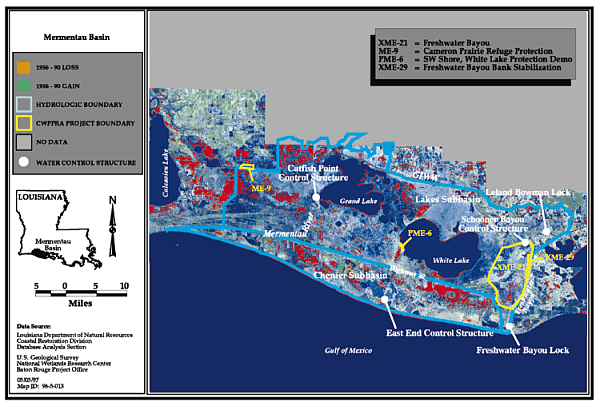
TABLE 26 - Anticipated Benefits and Costs of CWPPRA Restoration Projects in the Mermentau Basin.Four projects located in the Lakes subbasin the Cameron Prairie Refuge Protection, SW, Shore White Lake Protection, and Freshwater Bayou and Bank Stabilization have been designed to satisfy the objective of protecting interior shorelines and banks from further erosion. The Cameron Prairie Refuge (ME-9) project consists of a 6,000-foot rock breakwater along the northern bank of the GIWW. The project is intended to prevent vessel wake-induced erosion and scouring of fragile freshwater marsh vegetation, both emergent and submergent, along the GIWW. Another shoreline protection project in the Lakes subbasin, SW Shore, White Lake Protection Demonstration (PME-6), utilizes vegetative plantings to reduce erosion along an interior lake shoreline. The plantings are intended to slow wave erosion and capture sediment along a land bridge separating the open lake from fragile interior marshes. The Freshwater Bayou (XME-21) and Freshwater Bayou Bank Stabilization (XME-29) projects not only satisfy the basin’s objective of protecting interior banklines, they also serve the objective of protecting interior wetlands. These projects use combinations of a rock breakwater and water-control structures to reduce marsh loss in wetlands adjacent to the Freshwater Bayou Channel. The rock breakwaters are stabilizing the rapidly eroding west shoreline of Freshwater Bayou. The water-control structures will be used to protect interior marsh by reducing ponding and saltwater intrusion.
|
|
Figure 28. Mermentau Basin CWPPRA project boundaries and historical wetland loss/gain areas. |
Two CWPPRA demonstration shoreline protection projects have been selected as of January 1997 in the Mermentau Basin. One CWPPRA project in the Mermentau Basin, the Dewitt-Rollover Plantings Demonstration (ME-8) project, has been deauthorized. Designed to protect the Gulf of Mexico shoreline through the establishment of a vegetation community, it was hoped that this project would support the restoration objectives of protecting existing marshes and maintaining the basin’s geologic framework. However, monitoring results revealed that, because wave energies were too high for successful vegetation establishment, none of the vegetative plantings for this project survived (Vincent and Sun 1996), resulting in this project’s de-authorization. The other demonstration project, SW Shore, White Lake Protection Demonstration (PME-6) project, was approved on the third priority list. Featuring three rows of California bulrush plantings, this project is anticipated to protect a one-mile stretch of White Lake shoreline currently experiencing an erosion rate of 10 feet/year.
Construction has been completed, or partially completed, on four (out of five, total) of the CWPPRA projects selected on the first five priority lists in the Mermentau Basin. More detailed summaries of monitoring results collected as of January 1997 on these projects follow.
Calcasieu/Sabine Basin Restoration Objectives
|
|
Figure 29. Calcasieu/Sabine Basin CWPPRA project boundaries and historical wetland loss/gain areas |
The CWPPRA objectives in the Calcasieu/Sabine Basin (figure 29) are to preserve marshes by restoring natural hydrology, which reduces saltwater intrusion and tidal scour, and maintain the geologic framework of the basin by protecting shorelines from further erosion. Unlike hydrologic basins closer to the Atchafalaya and Mississippi rivers, major fluvial inputs are not available as a restoration tool in this basin and the potential for large-scale wetland creation is virtually nonexistent.
Therefore, the objectives for the Calcasieu/Sabine Basin are designed to utilize features that will protect and preserve existing marshes. While some objectives focus on maintenance of the basin’s perimeter integrity, others focus on interior marsh protection. The combination of selected projects address the basin objectives, take advantage of existing features within the basin, are readily implementable and have relatively minimal impact on navigation interests. Restoration objectives help guide the selection of appropriate CWPPRA restoration projects (table 27), and include:
CWPPRA Projects in the Calcasieu/Sabine Basin
A total of 13 CWPPRA projects have been approved for construction in the Calcasieu/Sabine Basin (table 27). The monitoring elements for those projects with monitoring plans completed by January 1997 and anticipated benefits and costs associated with these projects are summarized in tables 28 and 29.
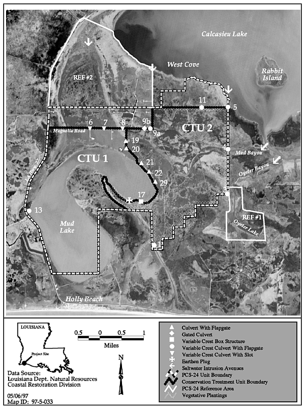
TABLE 29 - Anticipated Benefits and Costs of CWPPRA Restoration Projects in the Calcasieu/Sabine Basin.Several projects were designed to prevent or reduce saltwater intrusion into marshes from navigation channels in the Calcasieu/Sabine Basin. Saltwater from the Gulf of Mexico enters the basin via the Calcasieu Ship Channel, ultimately increasing salinity in Calcasieu Lake and the GIWW. The Cameron-Creole Watershed (FCS-17), Cameron-Creole Maintenance (C/S-4A) and Hog Island, West Cove Control Structure (XCS-47/48i) projects are designed to limit exchange with the Calcasieu Ship Channel and/or prevent pooling of saltwater within the project areas through the use of water control structures. The Cameron-Creole Watershed (FCS-17) project allows for the more efficient operation of the existing watershed protection project which has demonstrated the success of perimeter control restoration by reducing the energy levels and saltwater intrusion into a 113,000-acre tract. This area has experienced remarkable regrowth, especially in its fresher areas, reverting to acreages comparable to 1978 (USDA-NRCS 1997). Three projects, East Mud Lake (PCS-24), Brown Lake (C/S-9) and Highway 384 (PCS-25), are anticipated to protect marshes along the Calcasieu Lake. The East Mud Lake (PCS-24) project is designed to reduce salinity and water-level fluctuations associated with access canals connecting the project’s marshes with the southwest portion of Calcasieu Lake. The Brown Lake and Highway 384 projects will use both shoreline protection and water control structures to reduce the adverse effects of saltwater intrusion to marshes along northern Calcasieu Lake.
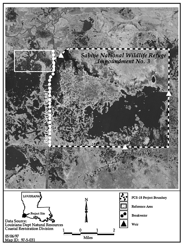
Saltwater intrusion is also threatening marshes in the northern portion of the basin along the GIWW. In order to protect the marshes in this area, it is important that the integrity of the GIWW spoil banks be maintained. Three CWPPRA projects, Sweet Lake/Willow Lake Hydrologic Restoration (C/S-11B), Clear Marais (PCS-27) and Perry Ridge Shore Protection (PCS-26i), will be implemented which satisfy the objective of reducing saltwater intrusion from navigation channels. The projects will utilize shoreline protection structures to reduce erosion along levees protecting freshwater and intermediate marshes from the higher salinity waters of the GIWW. These three CWPPRA projects will also employ water-control structures to reduce tidal scour within the project areas. An additional project, the Sabine Refuge Erosion Protection (FCS-18), utilizes a rock breakwater to protect a levee separating an impounded fresh marsh from surrounding higher salinity waters.
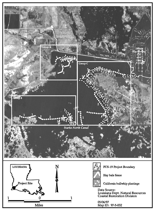
Two CWPPRA projects involve combinations of vegetative plantings with wave-damping techniques to prevent interior marsh loss and serve as innovative demonstration projects for future restoration efforts. The West Hackberry Plantings Demonstration (FCS-19) project uses vegetative plantings in combination with hay-bale fences to prevent marsh loss and protect shorelines. Another method of reducing wave energies in open-water areas is to construct terraces from dredged material. The CWPPRA Plowed Terraces Demonstration (XCS-56) project is designed to use this restoration technique to promote submerged and emergent vegetation growth in a shallow, open-water pond adjacent to the GIWW in Cameron Parish. A specially designed plow pulled by a marsh buggy will be used to create terraces where vegetation has died due to rapid water-level fluctuations, ponding and saltwater intrusion. This restoration technique could readily be used in other similarly affected areas. Similar state-funded efforts have demonstrated successful reduction in shoreline retreat rates and wave heights from terrace construction (LDNR 1994e). This innovative marsh creation technique could be used in other areas where shallow, open water exists adjacent to high-energy environments.
A deteriorated marsh adjacent to Black Bayou, Cameron Parish, will serve as the location for the Compost Demonstration (XCS-36) project. This project encompasses approximately 50 acres of shallow, open water and is intended to test the feasibility of using vegetative waste derived from yard clippings and tree cuttings to create wetlands in sheltered marsh pond areas. If successful, this disposal method could reduce current and future landfill needs as well as create vegetated coastal wetlands.
In the Calcasieu/Sabine Basin, construction has been completed on the Sabine Refuge Erosion Protection (FCS-18), the West Hackberry Plantings Demonstration (FCS-19) and the East Mud Lake (PCS-24) projects. More detailed summaries of monitoring results of these projects collected as of January 1997 follow.
|
|
Figure 30. Sabine Refuge Erosion Protection (FCS-18) project area map (adapted from Vincent 1995). |
|
|
Figure 31. West Hackberry Plantings (FCS-29) project areas showing locations of restoration features (adapted from Vincent and Sun, 1995). |
|
|
Figure 33. East Mud Lake (PCS-24) project are and features (adapted from Holbrook 1996b). |
Previous Section Contents Next
Section
Back to LA
Coast